Tuesday, December 29, 2009

Summary of December 23 - 27 Storm

The Christmas Snow of 2009 will be remembered by many in the country.  While we didn’t get much of the snow, the event was still memorable for us in mid-Missouri.  Here’s a wrap-up of the events, starting the night of the 22nd.

-- December 22 --


As the warm air mass lie just to our south, rain began to spread over the area overnight on the 22nd and early morning the 23rd.


Daily Precip 12/22:  0.39"

-- December 23 --


Rain fell modrately throughout the day on the 23rd, falling heavy at times.  The next map shows the distribution of thunderstorms that rolled through the area during the evening hours.


Daily Precip 12/23:  1.70"

-- December 24 --


During the morning hours, we caught a bit of a break from the rain.  During the afternoon though, the rain picked up again.  The big story today was the severe storms down in Louisiana, and snow falling in Texas and Oklahoma.  Dallas recorded their top December 1-day snow, with a total of 3".  Oklahoma City recorded 16" in a record-breaking one-day total.


Daily Precip 12/24:  0.59"
Daily Snowfall 12/24:  0.1"

As the low treveled north of the area, cold air spilled in from the west and changed the rain over to light snow.  We were greeted to light snow falling and a bit of snow on the ground Christmas morning.

-- December 25 --


The wind picked up overnight as the front passed, although not as bad as the blizzard conditions in Nebraska and Kansas.  Our top wind gust at this station was SSW at 25 mph early in the morning.

Our high temperature of 51° occurred just after midnight, and nine hours later we reached our low temperature of 17°.  We stayed in the upper teens and low 20s all day.  It was cold and windy!

As you can see in the next few maps, the low meandered a while in Iowa and northern Missouri.  As it did, it provided a steady snowfall throughout Christmas day.  Although it didn't accumulate much, it was perfect for a beautiful, yet easy to travel day in mid-Missouri.


Daily Precip 12/25:  0.04"
Daily Snowfall 12/25:  0.5"

-- December 26 --


The 26th was much like Christmas day, except not quite as windy.  Flurries and light snow fell through much of the day, accumulating a bit.


Daily Precip 12/26:  0.05"
Daily Snowfall 12/26:  0.5"

-- December 27 --


In this final map, moderate snow was falling the morning of the 27th.  There was a persistent band of moderate snow that lined up on I-70, with snow ending in Fulton a little after sunrise.  St. Louis felt the snow for longer in the morning.  This was our final, yet heaviest snow of the system.

Daily Precip 12/27:  0.11"
Daily Snowfall 12/27:  1.3"

Storm Total Precipitation:  2.77"
Storm Total Snow:  2.4"

Friday, December 25, 2009

White Christmas

It's been seven years since we last woke up to a white Christmas.  The snow storm that brought record-breaking snowfall to Texas and Oklahoma has pushed northward, allowing the cold arctic air to spill in and give us the snow we were dreaming of.  At daybreak, we only had a trace on the ground, but presently at 11:00 a.m. we have nearly an inch.  It's nothing to shake a wovel at, but it's enough to cover the ground.  And with my family all here, on Christmas...it's beautiful.

This is a storm that will be remembered for many years.  Check out Chris' CoCoRaHS blog to see the massive amounts of watches/warnings that were posted.  Everything from blizzard to tornado, this storm has had it all.  So far, this storm has kicked out 15 reported tornadoes in Louisiana and Mississippi, and over a dozen people have been killed in the blizzard.  A reminder of the power and danger of these storms. 

A current radar image shows the size of the storm. 


Ami, I heard you had a nice Christmas gift last night.  Can't wait to see your data online!  :o)

I hope everyone has a blessed and peaceful Christmas.

Monday, December 21, 2009

Traveling This Week? Read This!

Visit this blog for the latest on the storm to impact the midwest later this week.  You'll find some analysis of the storm and possible events to take place, PLUS suggested arrival times for cities around the midwest.  Much work was put into this post, so many thanks to Jeff and all the forecasters at KMIZ.

Saturday, December 12, 2009

Cold Start to December

Over the past six months, five of them (December included) have started out with below-average temperatures.  So far this month, we have only seen a high temperature exceed the average two times (from 12/1 - 12/11).


Attention should be drawn to December 8-10.  This was the timeframe of a major snowstorm that impacted a huge section of the upper-midwest.  Parts of Iowa, Nebraska, and Wisconsin got buried by snow up to 12" in places, and a widespread swath of 8-10".  Here's a great image of the snow cover.  Quite impressive.


Below are some links to area National Weather Service offices that were affected by the storm.  

Looking Ahead
The Climate Prediction Center still shows December giving us below-average temperatures, with equal chances of precipitation.  Local meteorologists are expecting small disturbances to move through the area, bringing small snow events, but nothing big.

Heavy Wind December 9

On December 9, I celebrated my 30th birthday with a max wind gust of..yep, 30 mph at the house.  In Auxvasse, we recorded 31.1 mph.  Sustained winds were anywhere from 15 - 25 throughout the night and day.

 Here's a summary of official wind gusts in the area from the NWS STL office.


LOCATION                  PEAK GUST (MPH)      TIME

ST CHARLES      (KSET)        58              902 AM
LITCHFIELD      (K3LF)        58              804 AM
ST LOUIS        (KSTL)        56              811 AM
CHESTERFIELD    (KSUS)        52              711 AM
ALTON           (KALN)        52              850 AM
HANNIBAL        (KHAE)        49              705 AM
WELDON SPRING   (KLSX)        49              750 AM
BELLEVILLE      (KBLV)        48              744 AM, 911 AM
JEFFERSON CITY  (KJEF)        48              750 AM
COLUMBIA        (KCOU)        47              738 AM
QUINCY          (KUIN)        47              643 AM, 935 AM
SALEM           (KSLO)        46              945 AM, 1025 AM
SULLIVAN        (KUUV)        45              925 AM
CAHOKIA         (KCPS)        45              852 AM
PITTSFIELD      (KPPQ)        44              706 AM
CENTRALIA IL    (KENL)        43             1005 AM
SPARTA          (KSAR)        39              225 AM, 1025 AM
FARMINGTON      (KFAM)        38              215 AM, 955 AM

Monday, December 7, 2009

First Accumulating Snow

Last night, we were treated with our first accumulating snow.  A weak system flew through the area during the evening hours, and around 8:00 p.m., we experienced light (moderate at times) snowfall.  It was enough to cover the cars and mostly cover the grass.  I was able to get outside after it stopped to measure how much had fallen.  Officially, we had 0.2" here, and 0.3" at school in Auxvasse.

Keep your eye on the graphic in the sidebar to the right.  I put the snow forecast graphic from the STL NWS office.  They update it a few times a day during active weather.  It does look like the low is going to track right in our back yard, successfully squelching any chances for a big snow event here.  For some good reading in the next few days, though, keep these blogs in your tabbed windows!  Our friends in Wisconsin are going to get a nice storm! 

Friday, December 4, 2009

Watching the Dec. 8-9 Storm

The season of anticipation has begun for me.  Missouri can be a very variable place for weather, and December can provide some impressive snow storms.  I'm hoping next week won't dissapoint (which was the story for last winter).

Up to this point, all reports about next week's storm has been favoring a southern track for the Low, with it passing through the SE corner of MO, through IL Northeastward.  This would put us in the shield of heavy snow on the NW side of the system.  Today's models however have trended the path more northwards, with the newest GFS model tracking the Low through Eastern KS, Central MO, and Northeastward.  This puts Nebraska, Iowa and Wisconsin in the crosshairs for the major event, which would be a welcomed sight from the snow-deprived bloggers in WI.

Unfortunately, that puts the Low tracking right over us, which would greatly decrease our chances for a major event.  Forecasters are still calling for below-freezing temps for much of the time period as a cold shot of air will be passing through just as the system arrives.  This may give us our first accumulation (and possibly still a snow day), but not a major event.

As always, much can change between now and Tuesday, and I'll keep the blog updated till then!

Wednesday, December 2, 2009

November Weather Summary

At the end of October's monthly summary, I mentioned that the CPC suggested that November would be drier.  They were certainly right, and had it not been for a strong storm dumping over 2" on us mid-month, we would have reported much drier conditions for November.  As I stated in a previous post, we experienced 16 days without measurable precipitation; this is on the heels of the wettest month of the year.  The more than two week respite from the rain provided a chance for the farmers to get out and harvest most of their crops.  We still have beans and corn standing in places.

As of today, we have not seen any snow here in Fulton.  There are places in Mid-Missouri that have reported a trace of snow, but none here.  Therefore, the November snowfall average of 1.6" was not met.  To my knowledge, we ran a deficit on snowfall every month last winter.  Look forward to more complete data this year.

Temperatures


November ranked 9th warmest on history for Columbia, as this data depicts.  We only had 6 days with a below-average high temp, and 23 days above-average.


Mean High / (average):   60.2 / (53.4)  +6.8
Mean Low / (average):  41.4 / (33.0)  +8.4
Mean Temp / (average):  50.8 / (43.2)  +7.6
High Temp:  76° on November 7
Low Temp:  27° on November 27


Precipitation

As stated before, we experienced a 16-day dry spell, which was abruptly ended by a 2.08" rain on the 15th (made the deer hunters pretty mad).  The 5-day precip total from the 15th - 19th was 2.86".  This means that 97% of our precip total for the month fell in this 5-day period.


Average monthly total for November:  3.85"
Actual monthly total for November:  2.94"
Deviation:  -0.91"

This is the first time we have had a deficit of precipitation since January.


Although we ran a deficit, we are still above the past two Novembers

For the year, we currently have a surplus of 15.98", which is unbelievable to me considering some people only get that much a year.  I am up to two years since I last watered my yard.  That's almost unheard of in Missouri, since we almost always have a grass-killing drought sometime each summer.


Data disaggregation of days with precip:


Missing something?  Snow graph.  Hopefully I'll have one for you next month.

First Snow Today?

There is a chance we could see our first accumulation here at MO-CW-1 in Fulton.  The forecast changed a bit overnight due to the track of the storm, but we still stand a chance to have some white on grassy surfaces by tonight.  At least we'll get to see the snow fall for the first time this year. 


Friday, November 27, 2009

December Outlook...Cold and Active??

Record cold October...check

Near record warm November...check

Record cold December?

I saw an interesting blog entry from the local TV station (KMIZ) tonight.  They frequently do a superb job of keeping the public updated with any potential weather threat as early as they can.  This particular entry caught my attention with the words "colder than average month, and very active as well".

Watch the video

This reminds me of the last significant snow event we experienced here in Fulton.  It was November 30 - December 1, 2006.  Fulton officially recorded 14.2" during that period.  Interestingly enough, I was watching the weather that day (no school that day obviously), when I saw an advertisement for CoCoRaHS on the local CBS station, it was the first I had heard of it.

Here is the great write up the NWS in St. Louis made on the storm.

They added an amazing satellite pic from the MODIS polar orbiting satellite that shows the grandeur of this awesome storm.  OSNW3, looking at your data, you managed to squeeze 1.1" out of the system.


(Source:  nasa.gov)

Follow the source link for higher-resolution pictures


Monday, November 16, 2009

October Re-visited

I'll start today's post with an interesting statistic for the year:

The wettest month this year was October -- with a total rainfall of 12.49".
Immediately following this, we experienced our driest period of the year, with 16 days of no measurable precipitation (>T)


After a very warm beginning to November, October is back with temperatures in the 40s and all-day rain events.  Some cooler air is spilling in behind the storm system bringing 5-8" of snow to Kansas.  Our first rain of the month came on the 15th with 2.08".  I thought we might actually have a month with below average precip, but I'm starting to think again.  These poor farmers in Callaway County are having a hard time getting their crops in.  There are still fields half-full of corn in places.

Tuesday, November 10, 2009

What Month is This?

It seems October and November made a switch this year.  What an amazing shift in weather!  The month of October, with its 12.49" precip total, under average temperatures, and even some snow to the upper midwest, gave way to the most pleasant beginning to November I can remember.  The past 9 days have simply been a delight.  We have enjoyed dry weather, sunny skies, and above-average temps every day so far.


We have gone 11 days now without any measurable precipitation, which is the first time since February 25th of this year.  With a 40% chance of showers today, we might be able to extend this dry spell even longer. 

I don't mind, as long as it gets cold and nasty by the time deer season rolls around.

Monday, November 2, 2009

An October To Remember

--- Updated 11/4 ---

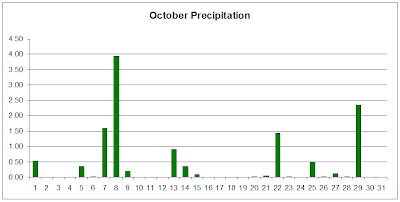
This summer was quiet in the world of weather blogs.  We have more than made up for it this month, though.  October 2009 brought with it record cold and wet weather.  We saw a couple mornings with frost early on, but for the most part, the temperature stayed above freezing overnight.  Here are some notable stats on the month:

  • We experienced 21 days with at least a trace of precip
  • Average Temperature:  50.8° *4th coldest October*
  • Total Precip:  12.49" *New Record for Fulton*
  • Fun Fact:
    • Every Thursday was wet
    • Every Saturday was dry <-- Correlation?

Click HERE for MO-CW-1 Daily Observations

Temperatures


We only exceeded the average high temperature 5 times this month.

Highest Temp:  75° on Oct. 20

Lowest Temp:  30° on Oct. 18

Mean High (average):  59.3° (68.0°)  |  -8.7

Mean Low (average):  42.4° (44.1°)  |  +1.7

Mean Temp (average):  50.8° (56.0°)  |  +5.2

Days Above Average High:  5

Days Below Average High:  26


Precipitation


Days with measurable precipitation:  18

Days with thunder:  5


Our yearly total so far.  The average yearly precipitation total for Fulton is 41.22"


Looking at a comparison of the past three Octobers gives you an idea of the huge month this has been.

Monthly Average:  3.25"


Finally, a data disaggregation of our precip this month:


Looking Ahead to November

Looking at the CPC models, a drier and warmer start to November seems to be the hand dealt to us.  I am glad for the break.  I'd like to take some time analyzing the past month some more.  I'm sure I'll want to know more about what happened a few years from now.

----.....----.....----.....----


Thursday, October 29, 2009

Weather Station Now Online!!

I am very excited this morning.  Our wonderful tech guy here at school has hooked up our new WMR-968 online.  I'm still playing with much of the formatting and such, but it will start shaping up soon.

The outside temp sensor and anemometer are still in my room (haven't had a chance to get them in an appropriate place outside yet), but they will be up soon.

The official school weather site is HERE.

For more detailed data and weather history for the station, click HERE.

Thursday, October 22, 2009

October Update

After recording the coldest start to October, we had a snippet of what we've been missing over the past few days. This week has given us sunny skies and temperatures in the 70s. We've been trying to get in all the outside time we can before these days are long gone.


The National Weather Service STL has updated their records through October 19, and Columbia is still recording the coldest average temperature, while St. Louis is recording the 2nd coldest. View their data here.


After recording 0.05" this morning, our October total tipped the 8" mark. We are currently above the yearly average by 5.89" with 2.5 months to go.

Friday, October 16, 2009

NOAA's Winter Outlook

Everyone's wondering what this winter will bring with El Nino in affect. NOAA has just recently published an article outlining what they believe this winter will look like. It'll be interesting to see how it pans out!

View the article here.


Source: NOAA


Source: NOAA

Thursday, October 15, 2009

Chilly and Wet Start to October

We are still two weeks away from Halloween, but the weather feels more like Thanksgiving. Our average high temperature this past week has been 52°, which is the normal high for November 19. Cloudy, drizzly, rainy. That's pretty much how you can describe October so far this year.

Some stats:

October 1 - 14
  • Mean Temperature (normal): 50.04° (59.43°)
  • Total Rainfall (monthly norm): 7.88" (3.25")
  • Days meeting/exceeding average high temp: 0
From the NWS STL website, these are the top ten coldest periods from October 1-14 in Columbia, MO:
  Value   Year
1 50.2 2009
2 51.0 1987
3 51.3 1988
4 51.8 1977
5 52.1 1917
6 54.3 1935
7 54.5 1964
8 54.7 1921,1952
10 55.0 1908
Finally, check out this month's temperature graph so far.

Friday, October 9, 2009

Storm Rain Total


Fulton Station, MO-CW-1: 5.72"

Auxvasse Station, MO-CW-5: 5.83"

**For a complete 3-day loop of this storm, visit OSNW3's blog entry October 11 Scroll to the bottom for radar loop**

Thursday, October 8


Friday, October 9

Thursday, October 8, 2009

Flooding Rain Today


Heavy rain has been affecting the area since late last night. I don't know what your favorite sound is, but mine is thunder in the morning. It can perk me up better than a finely brewed cup of coffee. This rain has come so quickly, and our ground was semi-saturated from the wet end of September and early October. Creeks and rivers have quickly filled their banks. The road by our house had 3-4" of water over it, and in the 6 years we have lived here, I have never seen it with water.

Morning observations (as of 5:30 a.m.)

Fulton Station (MO-CW-1): 1.59"
Auxvasse Station (MO-CW-5): 2.85"

I've been hearing word of students not able to come to school and some roads have been closed in the area.

Here are some local storm reports. I'll update as I get time today:

6:30 a.m. (Boone County) Several water rescues have occurred
6:55 a.m. (Callaway County) 6-8" of water on county roads


::Update::

So far at school (using an electronic rain gauge) we have experienced 4.25". I haven't checked my CoCoRaHS gauge yet, so I'm looking forward to seeing if the electronic gauge holds up.

Other reports:

3.82" reported at Sanborn Field at the MU Campus in Columbia
2.25" in Mexico, just north of here


Tuesday, October 6, 2009

Rain Intensity Table

I was doing some research on the water cycle for a class when I ran across this table on the USDA website. It quantitatively defines precipitation of different intensities, and I found it to be interesting.


An early October cold front gave me a nice wake up this morning at around 5:00. Lots of lightning and 0.35" of rain fell (as of 6:00) in response to the squall line. The parent Low pressure center is currently marching into Wisconsin giving our friends up there another soaking, giving them a relief from a dry September.

The snow returns on the national radar is becoming more common each day. It won't be long!

Thursday, October 1, 2009

September Weather Summary / WY 08-09 Summary

I'm pulling double duty on this month's summary. With the books officially closed on the 08-09 water year, I'd like to share some water year data with you. First, let's start with this month.

As in my previous post, this month shows more of the same in the precipitation department. We ran another surplus, but only after following a 31-day period of 0.31". Late in the month, an upper level low spinning in Colorado offered us the relief we needed, and my lawn responded with vigor! Each mow, now I am thinking, "Is this the last time?" Let's hope this weekend is the last.

Overnight, a warm front lifted NE through the area, giving us a milder start to the day than the previous few mornings (temps in the 60s rather than 40s), currently, there is a wide swath of rain and storms spreading from Texas to Missouri, and into Montana. Quite impressive indeed. There is thunder in the area, and we are sure to get the first precip of WY 09-10.

September Observations
can be found here

Temperatures

September offered us very comfortable temperatures. We started and ended the month a bit on the cool side, but we stayed around average through the middle of the month.

High: 83° on 9/11 and 9/27

Low: 44° on 9/29 and 9/30

Mean High (average): 76.2° (79.1°)

Mean Low (average): 57.0° (55.4°)

# of Days Above Average High: 6

# of Days Below Average High: 20


Precipitation

Average Precip: 3.68"
September Precip: 4.28"

And our yearly totals so far...


2007 - 2009 September Comparisons


In a comparison to the previous two years, you can see a remarkable difference in rain amounts. Last year, the tropics were extremely active, and we had two tropical depressions impact our area. One even came right through Missouri! The result of that is easy to spot on the graph. 2007, on the other hand experienced some extreme drought (if you'll remember, that was the same year with the devastating Easter Freeze).

September Days with Thunder: 2

I took some time over the weekend to generate some disaggregated data concerning rainfall amounts. I was interested to know the frequencies in which we experienced heavy/light rainfall events. I'm excited to have these data now. Thanks to OSNW3 for showing me some cool features on Excel.

January - August 2009
Days With Precipitation


Water Year 2008 - 09 Summary


Yearly Precipitation Average: 41.22"
WY 2008-09 Deviation: +6.00"


Links to Monthly Summaries:

January
February
March
April
May
June
July
August