It's not often we get snow on Christmas, and it's even less often that we get it two years in a row. Last Christmas, the middle of the country was graced with a powerful storm that spun into the area, sat on Iowa for a while, and went on its way, giving millions of people a white Christmas. Although we didn't measure much snow from that system, it was impressive and memorable. Here's a link from last year's post.
This year's storm was a different beast. It was faster, and gave us a beautiful wet snow all day Christmas Eve. We were in Rolla visiting my family, and watching the snow falling slowly through the bare trees was awesome. I took the liberty of bringing one of my extra rain gauges on our travel to measure the water content of the snow. It was a wet 9.3 : 1 ratio. Contrast that to the nearly 20 : 1 snow we had on the 11th. Geez, if this snow had that ratio, our snow total would have more than doubled. That made me wonder on our trip home...what is/are the factors that affect this ratio? I assume primarilly temperature. I also assume that one could accurately predict the type of snow based on this factor, which could end up saving cities money on salt/cinder they throw on the roads...but I digress.
In Rolla, I measured 2.8", which melted down to 0.30". In Fulton, we ended up with 3.5" melting down to 0.37". The roads are great...dry in fact, which I presume is a result of the wet snow. That's what led me to my inquiries above during our drive home today.
Merry Christmas!
Saturday, December 25, 2010
Thursday, December 16, 2010
Cold Start to December / Dec 16 Ice
We have experienced a colder than normal start to the month with a mean temperature of 26.0°, a -8.2° departure for the period of Dec. 1-15. As seen from the chart below temperatures have been below average, but of note are two periods of cold (4-8) and (12-15). Both brought breezy canadian air with it, and the latter gave us our 2" mini-blizzard on the 11th and 12th.

Ice Dec. 15-16
An upper-level disturbance is bringing snow to the upper plains and through to the east coast. As it developed, it brought light freezing drizzle/rain to our area. Barely enough to measure in the rain gauge, but it was enough to create a thin glaze on roads and elevated surfaces (enough to call off schools even). Below is this morning's radar showing the long band of snow affecting the nation.
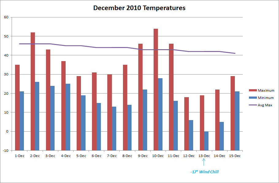

Sunday, December 12, 2010
Dec. 11-12 Winter Storm

(Source: NWS STL)
Update 8:00 a.m.
The snow ended early this morning and the wind didn't let up a bit all night. With gusts sustaining in the upper 30 mph range, it made for some difficult snow measurements this morning. I made multiple measurements around the yard, and came up with a 2.0" total. This storm reminds me of the January 6-7, 2010 storm. Strong NW winds made similar drifting patterns, although more exaggerated due to double the amount of snow then. Pictures from that storm can be found here. Compare those with this year's storm.
Here are a couple of pictures from the storm:


Update 12:00 a.m.
Snow is currently falling with vigor in Missouri again. After much anticipation, we will reach our first inch tonight. We reached our maximum temperature of 46° around 10:00 am, and by 10:00 pm we were at 17°. Morning rain changed to a mist, and then quit for a while. Around 2:00 we started seeing flurries flying around, which intensified bit by bit through the evening hours. Tonight, at 12:00 am snow is falling at a moderate rate and wind gusts are reaching 40 mph. The current temp is 16°.
I tried to make a measurement, and my best estimation is a current depth of 0.5". Below is a video I shot and the coinciding radar image at 11:45 pm.

Tuesday, December 7, 2010
November Weather Summary
The dry weather continues this month. After an extremely arid 0.54" total for October, we ended up with a slightly better 1.74" for the month of November. The dry months stick out to us lately, since we haven't really experienced any prolonged stretches of dry weather patterns in the past three years. I did a quick data check. Over the past 36 months, 27 of them have exceeded the normal precip amounts, and only 9 have had deficits. The months with deficits, ranging from 1/2008 - 11/2010 are:
Aug 08
Nov 08
Jan 09
Nov 09
Mar 10
May 10
Jun 10
Oct 10
Nov 10
It's interesting to note that the past three Novembers have run on the low side of precipitation.
Temperature

Mean Temp: 45.9°
Deviation: 2.7°
Maximum: 75° on Nov. 10
Minimum: 18° on Nov. 26
Precipitation

Average November: 3.85"
Actual November: 1.74" (-2.11")
Days with measurable precip: 7
Snow
We did see our first flakes of the year on the 30th. Some midday flurries and light snow just blew around, but made for a welcomed sight for me. It's hard for me to imagine, but our average snowfall for November is 1.6"
Other Weather Info:
Days with thunder: 2
Days with fog: 1
Days with wind gust (>= 20 mph): 20
Friday, December 3, 2010
Supercell Pictures
http://www.dailymail.co.uk/sciencetech/article-1334672/Jaw-dropping-image-enormous-supercell-cloud-Glasgow-Montana.html
Follow this link for some awesome July storm pictures from storm photographer Sean Heavey
Follow this link for some awesome July storm pictures from storm photographer Sean Heavey
Tuesday, November 30, 2010
First Flakes of the 2010-11 Season!
At 11:00 a.m. today the alarm went off. 20 pre-teen students went nuts at the sight of our first flakes falling from the sky. All learning ceased for a good 5 minutes as they postulated the probability of getting out early as their calm (but equally as excited) teacher tried to explain how the dynamics of the storm wouldn't allow for much snow to fall...but to no avail.
A strong storm system to our north brought us a relatively dry cold front. With it came a steep decrease in temperature, and sharp gusty winds from the NW. We got some good flurries and a light snow shower between 11:00 and 11:45 am.
A strong storm system to our north brought us a relatively dry cold front. With it came a steep decrease in temperature, and sharp gusty winds from the NW. We got some good flurries and a light snow shower between 11:00 and 11:45 am.
Wednesday, November 24, 2010
Winter Storms
The dry weather pattern that has dominated our region for the past 60 days is beginning to ease up. After 56 days of only 0.99" of precip, we have enjoyed three days in a row with rainfall, and two of them graced us with thunderstorms.
On Monday, you could feel the moisture in the air all day as a strong southerly WAA was in effect. The trailing cold front brought some strong storms to the area. In Auxvausse, the rain and wind was pretty intense, but at home I only found 0.06 in the gauge. Our wind topped 40 mph with the strongest storm.
This morning, we have had steady light to moderate rain with embedded storms, although not as strong as Monday's. The main feature of these storms is heavy rain. We have ponding in our back yard this morning, not because of large amounts of rain, but rather because of our extremely dry semi-impermeable clay soil.
Awaiting a strong cold front tonight. Should be a brisk day tomorrow!
Wednesday, November 10, 2010
Dry and Pleasant Start to November
So far, the November weather pattern has followed suit with what we've been experiencing the past month and change. We are on day 16 with no rainfall, and of the past 46 days, only 0.54" of rain has fallen. We haven't experienced this type of aridness since the summer of 2007. There are currently no immediate impacts that I can forsee of our lack of moisture. There are places in Missouri, however that are drier than us and are in need of groundwater recharge.
Oh, but the changes are a comin. With the passage of a weak cold front tonight, the cards are set for a colder and more active weather pattern. High temperatures will most likely stay at or below normal for most of the rest of the month, and we may even see our first flakes of the year.
Diurnal Temperature Variations
Thanks to a comment on Bob's blog, posted by OSNW3, I was curious to know what our diurnal temps do throughout the year. I must admit, I never thought of it before. Interesting stuff indeed. Here's what I found out.

As expected, the transitional months of Mar/Apr, and Sep/Oct contain the highest amount, with the more steady temperatures occurring in the summer and winter months. In winter, we can see days where the temperature doesn't move but a few degrees in a 24 hour period. The dense air masses that invade the area, and prevalent cloud cover throughout no doubt have an impact on this. I was a bit surprised with November, as there's a pretty extreme drop off from the beginning to the end of the month. I'm sure the increase in cloud cover that occurs during this month has a part in this equation as well. Lots to think about on this one!
Saturday, November 6, 2010
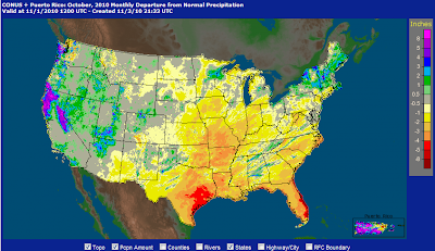
October Weather Summary
What a change we experienced this month! A quick look at our data throughout the year, and October will stick out. Dry and warmer-than-average is the best way to summarize the month. We have had only 0.54" recorded over the past 41 days, and 71% of those days recorded higher than average max temps. The dry and warm weather couldn't have come at a better time, as the regional farmers were given ample time to get in their crops. Most are done now, and have started in on their winter work.
We had our first frost on Oct. 4th
Our first freeze occurred on Oct. 29
Temperature
The above average temperatures were incredible. It gave us a longer than normal transition period between summer and winter. Usually in this region we get about 10 days of "chamber of commerce weather" before cold/windy days arrive.

Mean Temp: 59.5°
Deviation: 3.4°
Maximum: 85° on 8-Oct
Minimum: 28° on 29-Oct
Precipitation
Not much happening here. As you can see in the graphic below, much of the country had dry rain buckets, with extremes in SE Texas and Florida.


Check out the contrast between last year and this year.
Other Weather Info:
Days with thunder: 1
Days with fog: 4
Days with wind gust (>= 20 mph): 16
A final count on mowing the yard: 22. Kids in the neighborhood here charge ~$20 per yard. That's a pretty good haul for a teenager, especially if you have the time to work several houses through the summer.
We had our first frost on Oct. 4th
Our first freeze occurred on Oct. 29
Temperature
The above average temperatures were incredible. It gave us a longer than normal transition period between summer and winter. Usually in this region we get about 10 days of "chamber of commerce weather" before cold/windy days arrive.

Mean Temp: 59.5°
Deviation: 3.4°
Maximum: 85° on 8-Oct
Minimum: 28° on 29-Oct
Precipitation
Not much happening here. As you can see in the graphic below, much of the country had dry rain buckets, with extremes in SE Texas and Florida.


Average October: 3.25"
Actual October: 0.54" (-2.71")
Days with measurable precipitation: 4


Check out the contrast between last year and this year.
Other Weather Info:
Days with thunder: 1
Days with fog: 4
Days with wind gust (>= 20 mph): 16
A final count on mowing the yard: 22. Kids in the neighborhood here charge ~$20 per yard. That's a pretty good haul for a teenager, especially if you have the time to work several houses through the summer.
Thursday, October 28, 2010
First Freeze 2010 / YouTube Channel
It seems that our first freeze will occur tonight and tomorrow morning. The historic cyclone that set records and wreaked havoc for much of the country also brought with it some cold, dense air. The ridge of high pressure, coupled with a light wind will provide us with our first freeze of the year.

Wxwtchr YouTube Channel now online!
Thanks to OSNW3 and Bob for the idea, I started a channel for this station in Fulton. I posted a video tonight (the rest are on my work computer). But now that we have an upgraded system at home, you can expect much more to come!

Wxwtchr YouTube Channel now online!
Thanks to OSNW3 and Bob for the idea, I started a channel for this station in Fulton. I posted a video tonight (the rest are on my work computer). But now that we have an upgraded system at home, you can expect much more to come!
Monday, October 25, 2010
Sounds and Smells of Spring
You know the smell I'm talking about. The moist, complex smell that is so prevalent in April and May. Birds are singing their encouraging melodies, dew points are in the 60s, and storm spotters are put on alert.
The past couple of days have been very spring-like. Saturday, St. Louis recorded a record high low temperature of 67 degrees (2 degrees above the normal high). Hail reports clogged the NWS phone lines last night as a line of storms invaded the I-44 corridor from Rolla, MO to Illinois.
 Stormy Night
It's not often we see these icons on our forecast page, let alone at the end of October. Although a severe event is not out of the question any given year, it certainly does catch you by surprise.
A powerful cold front is driving through Missouri tonight, bringing with it a squall line with embedded mesocyclones that are likely to produce some tornadoes (according to the latest evening HWO discussion). The quick pace of the front and resulting speed of the storms adds a higher degree of urgency if storms do turn severe.
 As of 10:05 p.m., the squall line had started to develop, as seen here in the watch product. A very large area is under the gun until 6:00 a.m.
The past couple of days have been very spring-like. Saturday, St. Louis recorded a record high low temperature of 67 degrees (2 degrees above the normal high). Hail reports clogged the NWS phone lines last night as a line of storms invaded the I-44 corridor from Rolla, MO to Illinois.
It's not often we see these icons on our forecast page, let alone at the end of October. Although a severe event is not out of the question any given year, it certainly does catch you by surprise.
A powerful cold front is driving through Missouri tonight, bringing with it a squall line with embedded mesocyclones that are likely to produce some tornadoes (according to the latest evening HWO discussion). The quick pace of the front and resulting speed of the storms adds a higher degree of urgency if storms do turn severe.

Wednesday, October 20, 2010
October Lull
This October is proving to be a very dry one, indeed. We haven't been impacted with any notable weather system the entire month. It has resulted in a beautiful month with plentiful sunshine. The Indian Summer ended, and we are back to normal temps now. For the 20 days so far this month, we have had 1 day of measurable precipitation, which brings our monthly rain total to 0.07". A far cry from last year's October total of 12.49" (18 days of measurable precip).
Unsettled weather is expected to join us again for the last week of the month. Depending on the strength of the systems, it could still pull us up close to our average for the month.
Unsettled weather is expected to join us again for the last week of the month. Depending on the strength of the systems, it could still pull us up close to our average for the month.
Tuesday, October 12, 2010
Indian Summer Coming to and End
Although I can't find specific thresholds defining the beginning and end of an Indian Summer, I can say with confidence that our current warm period is coming to an end. After our first frost on Oct. 4th, and another frost on the 5th, our skies cleared and temperatures stayed well above normal for a 6 day period. High pressure settled in the mid-section of the nation, keeping millions high and dry for the beginning of October.
A strong system from the NW has finally provided enough kick to move that airmass out of the area, and we are experiencing more seasonal cloudy, rainy, and normal temperatures for the mid-section of the week.
A strong system from the NW has finally provided enough kick to move that airmass out of the area, and we are experiencing more seasonal cloudy, rainy, and normal temperatures for the mid-section of the week.
Thursday, October 7, 2010
September Weather Summary
Well, this September symbolized all I love about the fall in Missouri. We experienced strong thunderstorms, heavy precipitation, plenty of windy days (1 out of 3 days had wind gusts >= 20 mph), and a nice cool-down that brought air as fresh and crisp as the ripe Missouri apples we've been enjoying.
An interesting fact about this September. On Sep. 19, we had a 1.18" rain that put us just over our yearly average of 41.22". Every drop of rain from here out is a surplus, which has been the norm since 2008. Last year, we hit our average yearly precip total on October 7.

Year / Amount Surplus
2008: 18.66"
2009: 17.00"
2010: 2.15" (as of 9/30)
Temperatures
It really was a tale of two seasons, and as I remarked in a previous post, the delineation between summer and fall was quite easy to notice, and can be seen on the graph below. September 24 was a good "first fall" day (although I have no quantitative formula to back that up)
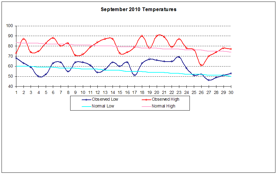
Mean Temp: 69.1°
Deviation: +1.8°
Maximum: 90° on Sep. 18
Minimum: 46° on Sep. 27
Precipitation
Once again, we have been inundated with heavy precipitation. Those living in flood plains have had a rough three years, and there were many farmers in the area that lost entire fields of crops due to a late-year flood right before harvest time.

Average September: 3.68"
Actual September: 8.26" (+4.58")
Days with measurable precipitation: 13


Other Weather Info:
Days with thunder: 4
Days with fog: 9
Days with wind gust (>=20 mph): 10
Yearly Totals:
Thunder: 44
Fog: 43
Wind Gust: 58
Mows: 20
Coming Soon...Water Year 2009-2010 Summary
Monday, October 4, 2010
First Frost of 2010
A cool Canadian high pressure system and a clear sky brought us our first frost over night. At this station, we dropped to 36° around sunrise today (10/4). Frost was fairly thick on the roof of my car and other elevated metallic surfaces. I welcome the cool weather with open arms!
Sunday, October 3, 2010
The Chill is Back!
Note: I had hoped to get the September Weather Summary and 09-10 Water Year summary posts in tonight, but needed to do some data entry for CoCoRaHS. I had computer issues this summer, and was without access for most of the summer. We're back online now, but the data entry took longer than expected. I'm hoping to get the summaries up soon...lots to talk about.
But for now, a quick commentary on mid-Missouri weather as of October 2nd
Since I was young, I've always pondered the official beginnings of the season according to the calander. My birthday lands on December 9 which to me has always felt like winter. Snow, cold, no leaves...winter. It always confused me that it is still fall until just days before Christmas.
I think, however that the Autumnal Equinox is a very good dividing line many years that marks the beginning of fall. When the wind shifts to the north, it brings drier and cooler air than it has for the past few months. The freshly-cut corn and bean fields fill the air with the memories of hay rides and fall festivals. This year was no different. We topped out at 90 degrees this September, with many more days in the mid to upper 80s throughout much of the month. But the last week or so was just plain nice. Tomorrow night, we will even have a chance for our first frost to greet us. This is fast becoming my favorite time of year.
I have a lot to talk about in my September summary, which is why I'm choosing not to write the post now. Some highlights are the high temperatures, reaching our yearly rain total this month, and some ponderings on the increasing rain intensities over the past 30 years.
Oh, and we're up to 20 mows now. Hopefully we're getting close!
Wednesday, September 8, 2010
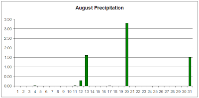
August Weather Summary
This past month is easy for me to summarize: Hot and sticky. I know...kinda goes with the territory for mid-Missouri in the summer, but it was just nonstop this year. It's possible that I've just been spoiled with the fantastic summers of 2008 and 2009. We spent much of August this year under a heat advisory, and spent a two-week period with daily Heat Indices at or above 100°. Not only is that uncomfortable, but it's also dangerous. Heat is the #1 weather-related killer in the country.
Temperatures
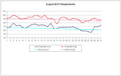
Notice the beginning of the month. Although we didn't get close to records, the constant heat was very uncomfortable.
Mean Temp: 79.6°
Deviation: +4.0°
Maximum: 99° on Aug. 3, 10, 13
Minimum: 55° on Aug. 28
As a side note, the maximum dew point recorded this month was on Aug 9 at 79°
Precipitation
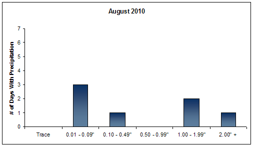
Yes, the temperature was the big story of the month, but making its appearance in the shop talk was once again what a wet summer we are having. For the third year in a row, we have experienced above-average rainfall amounts. So far, for the period of June - August, we are 4.91" above the 30-year mean. With only 7 days with measurable precip, we ended up with a total of 6.80" this month (about half of that fell on Aug. 20 alone).


Other Weather Info:
Days with thunder: 4
Days with fog: 4
Days with wind gust (>= 20 mph): 4
Number of mows: 19
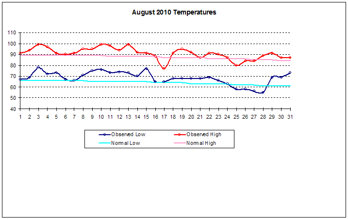
Mean Temp: 79.6°
Deviation: +4.0°
Maximum: 99° on Aug. 3, 10, 13
Minimum: 55° on Aug. 28
As a side note, the maximum dew point recorded this month was on Aug 9 at 79°
Precipitation
Yes, the temperature was the big story of the month, but making its appearance in the shop talk was once again what a wet summer we are having. For the third year in a row, we have experienced above-average rainfall amounts. So far, for the period of June - August, we are 4.91" above the 30-year mean. With only 7 days with measurable precip, we ended up with a total of 6.80" this month (about half of that fell on Aug. 20 alone).

Average August: 3.64"
Actual August: 6.80" (+3.16")
Days with measurable precip: 7

Other Weather Info:
Days with thunder: 4
Days with fog: 4
Days with wind gust (>= 20 mph): 4
Number of mows: 19
Tuesday, August 10, 2010
July Weather Summary
July ended with a warm and wet tone in the books, although if you were to guess, it would seem hot and dry. Even with 13 days of precipitation, it didn't seem like it was overly wet (at this station). Still, it was no typical July, but it has fallen in line with the past two years. Although we were much cooler last year, we also recorded a surplus of +2.36" (this year was +2.83").
Temperature

Mean Temp: 79.6°
Deviation: +2.1°
Maximum: 96° on July 14
Minimum: 56° on July 2
Precipitation

Average July: 4.12"
Actual July: 6.95" (+2.83")
Days with measurable precipitation: 13


Other Weather Info
Days with thunder: 10
Days with fog: 3
Days with wind gust (>=20 mph): 4
# of Mows so far this year? 14
Wednesday, July 21, 2010
Severe Storm July 20
For the past three days, a line of strong and severe storms have raced through our area bringing with them very heavy rain, lots of lightning, and strong winds. Sunday morning's storm brought with it some hail in addition. We missed out on Monday's storm, but it knocked down a barn 20 miles north of us. Tuesday's storm is the topic of this post. The storm hit around 7:30 a.m. and had lots of lightning, and the strongest winds I've seen since my 6 years in Fulton. Officially at this station, we recorded a NW wind at 48.3 mph. Now the anemometer is in a somewhat sheltered area given the houses around us, so I would bump that speed up for accuracy. After the initial storm passed, light rain fell for about 2.5 hours. Rainfall totaled 1.02" for the morning.
At night, we had another storm roll through, bringing our daily total to 1.32"
Below are pictures of the damage to the neighborhood. Anything that wasn't secured down was blown out of yards. Multiple trees, up to 12" in diameter were snapped in half, and those folks with 6' privacy fencing lost sections. The van across our street was damaged by a flying piece of fence. The storm was apparently at its worse over southern Fulton (including my neighborhood). Where I work, on the north side, we didn't have a single twig on the ground. But as I drove home for lunch, I saw more and more limbs on the side of the road.


One of the damaged fences
Saturday, July 3, 2010
June Weather Summary
So far, I can say that the past few summers have just been plain nice in Missouri. We are still experiencing days with dew points topping 70°, but temperatures haven't been that oppressive (which can be a typical talking point for Missouri loafers). The last time we officially hit 100° was August 16, 2007 (according to the NWS Columbia Station). I remember 2007 as an intense summer. We had a string of 20 days at or above 90° (from 7/31 - 8/19), and if I remember right we had a minor to moderate drought in parts of Missouri. I remember a funny scene on the news that summer. The Governor was giving a speech at a Mid-Missouri farm announcing the release of state emergency funds for the drought...in the middle of a tropical downpour!
All that being said, we have enjoyed a couple of nice years, but the law of averages are not pointing in our favor. And traditionally July and August are our toughest months.
Dew Point
I am interested in keeping track of the amount of moisture in the air throughout the year (by means of dew point temperature). Although I could manually check the hi/low Td for each day as I do with the temperature, I'm not convinced I would stay disciplined enough to keep steady data (feeling overwhelmed as I do often). For now, a glance of nighttime temps will suffice, as a lower Td will allow for more cooling overnight. This month, we had 10 days with a nighttime low at or above 70°. That makes for some sticky weather -- or "Air you can wear"-- as one local meteorologist puts it.
Temperature
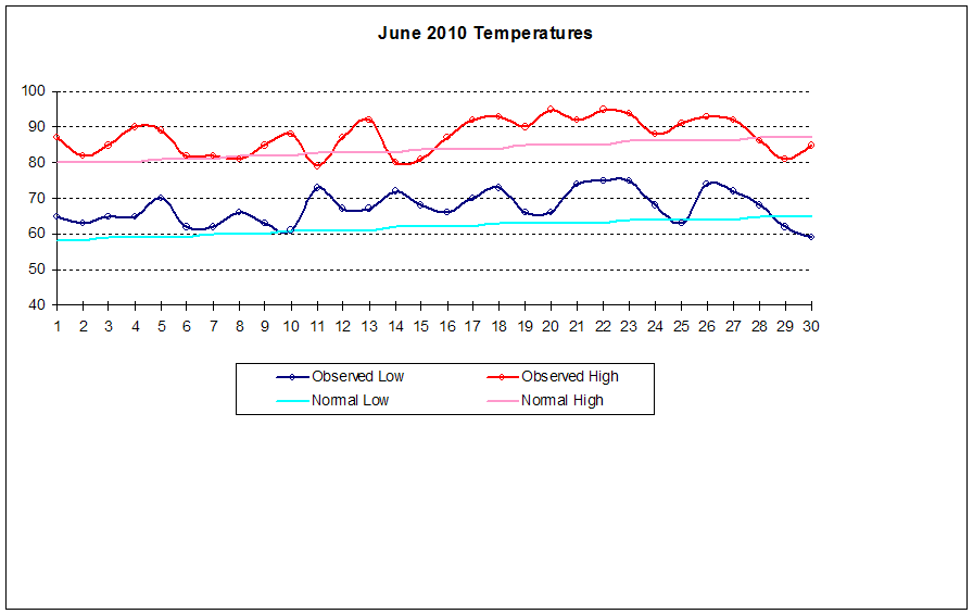
Mostly above average this month. We had 23 days with a high exceeding the average, which helped bump up our mean temp quite a bit over the 30 year average.
Mean Temp: 77.4°
Deviation: +4.7°
Maximum: 95° on Jun. 20
Minimum: 59° on Jun. 30
Precipitation
Interspersed as it was, we still didn't hit the mark this month. Pop-up showers and thunderstorms were the norm in Missouri this month, so extreme differences can be found from station to station. We weren't that lucky, although we did receive our fair share. The lawn looks the brownest that it has in three years (which is its normal dormancy period for MO). I don't mind much because it gives the mowing a little respite.

Average June: 3.87"
Actual June: 2.79" (1.08)
Days with measurable precip: 12

Other Weather Info
Days with thunder = 7
Days with fog = 1
Days with wind gust (>= 20 mph) = 5
Our lawn mowing count is up to 10 for the year. I'm still thinking the total might top out at around 18...we'll see.
Random Photos and Video
Below is a video I shot shortly after sundown on May 24. The lightning was simply beautiful that night, so I couldn't help getting video of it. The camera view is facing ESE.
Other photos I have are ones that I've snapped over the summer. There are plenty, but I chose only a sampling. Enjoy!


All that being said, we have enjoyed a couple of nice years, but the law of averages are not pointing in our favor. And traditionally July and August are our toughest months.
Dew Point
I am interested in keeping track of the amount of moisture in the air throughout the year (by means of dew point temperature). Although I could manually check the hi/low Td for each day as I do with the temperature, I'm not convinced I would stay disciplined enough to keep steady data (feeling overwhelmed as I do often). For now, a glance of nighttime temps will suffice, as a lower Td will allow for more cooling overnight. This month, we had 10 days with a nighttime low at or above 70°. That makes for some sticky weather -- or "Air you can wear"-- as one local meteorologist puts it.
Temperature
Mostly above average this month. We had 23 days with a high exceeding the average, which helped bump up our mean temp quite a bit over the 30 year average.
Mean Temp: 77.4°
Deviation: +4.7°
Maximum: 95° on Jun. 20
Minimum: 59° on Jun. 30
Precipitation
Interspersed as it was, we still didn't hit the mark this month. Pop-up showers and thunderstorms were the norm in Missouri this month, so extreme differences can be found from station to station. We weren't that lucky, although we did receive our fair share. The lawn looks the brownest that it has in three years (which is its normal dormancy period for MO). I don't mind much because it gives the mowing a little respite.

Average June: 3.87"
Actual June: 2.79" (1.08)
Days with measurable precip: 12

Other Weather Info
Days with thunder = 7
Days with fog = 1
Days with wind gust (>= 20 mph) = 5
Our lawn mowing count is up to 10 for the year. I'm still thinking the total might top out at around 18...we'll see.
Random Photos and Video
Below is a video I shot shortly after sundown on May 24. The lightning was simply beautiful that night, so I couldn't help getting video of it. The camera view is facing ESE.
Other photos I have are ones that I've snapped over the summer. There are plenty, but I chose only a sampling. Enjoy!


Sunrise - June 27, Montauk Springs

The garden so far. We've got peppers that are close to being ready,
lots of green tomatoes, and squash comin out of our ears!
Friday, June 11, 2010
June 8 Shelf Cloud
June has been relatively active for Missouri. While we have experienced average precip here, the poor folks in northern MO have had an extremely wet 14 days. Estimates for extreme northern MO are up to 10" according to the AHPS Precipitation Analysis team.
The purpose of this post, however is to share one of the most exciting clouds I've witnessed. On the morning of June 8th, around 11:00 a.m., a rather large complex of storms eased its way southeast. After hearing reports of a wicked shelf cloud 30 minutes ahead of the actual storm, I grabbed the camera and waited outside. I was not disappointed! I made an attemt (my first) at pasting together a panoramic of the clouds, but believe me the picture doesn't do the cloud justice. This was amazing.

The purpose of this post, however is to share one of the most exciting clouds I've witnessed. On the morning of June 8th, around 11:00 a.m., a rather large complex of storms eased its way southeast. After hearing reports of a wicked shelf cloud 30 minutes ahead of the actual storm, I grabbed the camera and waited outside. I was not disappointed! I made an attemt (my first) at pasting together a panoramic of the clouds, but believe me the picture doesn't do the cloud justice. This was amazing.

(For a larger view, click on the picture)
May Weather Summary
Since the last post, May dried off and heated up. We enjoyed some sun at the beginning of the month, a wet--although not over the top--middle, and by the end, we were getting a nice welcome into summer.
Temperature

Mean Temp: 64.7°
Deviation: +1.0°
Maximum: 91° on May 24
Minimum: 41° on May 8
Precipitation

Average May: 4.97"
Actual May: 4.23" (0.74")
Days with measurable precip: 12

Even with 12 days of measurable precipitation, we still came under the mark for the month. This is partly due to the fact that we didn't have any 1" events, but rather more moderate amounts as shown in the above graph. Compare this with last year's totals below. We had 12 days of measurable precip, but over an inch more rain filled the bucket.

Other Weather Info
Days with thunder: 10
Days with fog: 4
Days with wind gust (>= 20 mph): 5
As of today (June 11), we've mowed the yard 7 times.
Tuesday, May 18, 2010
A Soggy Eight Days
May has been tricky this year. We started out with clear blue skies, and for the most part above average temperatures. But the last eight days have been a much different story. While it hasn't come in abundance each day, it has rained on and off - sometimes very heavy, sometimes just a steady mist. But the fact remains that it has soaked us. The eight day total is 3.45", which is 69% of our May average.
Some Mid-May Stats:
(May 1 - 17)
Mean Temp: 59° (2.6°)
Precip Total: 3.69"
Days With Thunder: 7
Days With Fog: 3
Days With Wind Gust (>= 20 mph): 5


As of today, I've mowed the lawn 4 times. The chives are looking beautiful - I'll have pictures of them on my monthly summary. Not a cloud in the sky today...I'm looking for some time to dry out!
Saturday, May 1, 2010
April Weather Summary
-----** Additional Yearly Data Updated on 5/5/10 **-----
April in Missouri can be a wild time. The transition between Winter and Summer can cause some intense battles between air masses, and the midwest is fortunate (or, depending on your view--unfortunate) to receive the brunt of these clashes. While we did have a couple of very weak tornadoes in and around the area, there was no real severe weather to write home about. April can be split up into three segments this year: Wind, warmth, and water.
Wind
50% of the month could be classified as "breezy" (gusts =< 20 mph), as we experienced 15 days meeting that criteria. The first 8 days of the month were incredibly breezy, as they finished off a 10-day period of windy weather. The top wind gust of 40 mph occurred on April 23rd as a strong bow echo passed through. You can view the data HERE.
Warmth
Take a look at the temperature graph. You'll see that of the first 15 days, we experienced a high temperature below average only once. The high temperature during those 15 days averaged at 77.5°, where the normal average high for that period was 63.6°, a 13.9° difference. OSNW3 experienced the same warmth in Wisconsin. For his perspective of April from the upper-midwest, click HERE.
Water
The last 10 days of the month experienced an active weather pattern that brought most of our monthly precip total. Collectively, we recorded 2 days with precip above 1", with our one-day max occurring on the 24th of 3.02". We exceeded our monthly average by 2.58".
Temperature

Mean Temp: 60.9°
Deviation: +6.5°
Maximum: 87° on Apr. 1
Minimum: 36° on Apr. 9
Precipitation

Average April: 3.96"
Actual April: 6.54" (+2.58")
Average April Snow: 0.6"
Actual April Snow: 0.0" (0.6)
Days With Measurable Precip: 11

As the year goes on, count on seeing more bars on the heavy side of the graph.
To compare this April with the past two years:

Other Weather Info
Days With Thunder: 7
Days With Fog: 4
Days With Wind Gust (>= 20 mph): 15
Yearly Weather Info
With the year a quarter of the way done, here's some miscelaneous data:
Max Temp: 87° on Apr. 1
Min Temp: -5° on Jan. 9
Greatest 1-day Precip: 3.02" on Apr. 24
Greatest 1-day Snow: 5.4" on Jan. 6
Days With Thunder: 11
Days With Fog: 21
Days With Wind Gust (>= 20 mph): 28
# of Mows: 2
Subscribe to:
Comments (Atom)