Friday, February 27, 2009

Larger Hail Pad Picture...Snow Still Forecasted

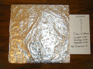
I'm still new at blogger, and I can't figure out why I can't enlarge my pictures on the previous post, so I'm creating one just for them. This way, you could view a larger version of them.


Snow is still forecasted to arrive early Saturday morning. Both the National Weather Service discussions and local meteorologists are in agreement that the low will maintain and slightly strengthen as it swings through western Missouri. Current forecast models are bringing the heaviest snow (3-4") just to our west, leaving Fulton in an area that may receive 2-3".


Visit the KMIZ blog and NWS St. Louis Winter Graphics page for further updates...I am.

Thursday, February 26, 2009

Pictures From the Storm

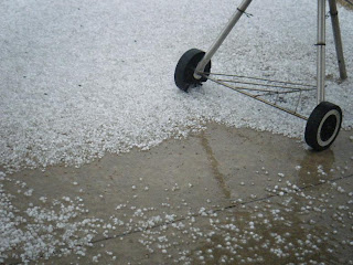
My wife is amazing. I called home to see how the girls fared in the storm, and she told me that she had taken pictures and noted the time the hail began! So it's because of her that I can see what I missed while I was at work. She is awesome.

She took some great pictures...enjoy.


Here are a couple of pictures from the hail pad. On the official report, I entered an estimated 360 indentations. I got the number by blocking off a 2" x 2" portion of the pad and multiplying to get a rough estimate.


I also estimated the largest hail size based on the photos and the largest dents on the pad. There was a giant dent in the upper right quadrant of the pad. It is easiest to see that on the photo with the flash.


Local Storm Reports

Here are some local storm reports from this morning's storms:

Time / Size of Hail / Location

  • 7:24 a.m. -- 0.25" -- 2 Miles S. Columbia
  • 7:35 a.m. -- 0.50" -- 1 Mile SE. Columbia
  • 7:36 a.m. -- 0.25" -- Columbia
  • 7:40 a.m. -- 0.70" -- Columbia
  • 8:07 a.m. -- 0.70" -- 2 Miles W. Jefferson City
  • 8:10 a.m. -- 0.70" -- 1 Mile NW Jefferson City
  • 8:13 a.m. -- 0.25" -- 2 Miles NNW Jefferson City
  • 8:29 a.m. -- 0.25" -- 2 Miles W New Bloomfield
  • 8:30 a.m. -- 0.25" -- 2 Miles W Guthrie
  • 8:35 a.m. -- 0.25" -- Mexico
  • 8:51 a.m. -- 0.25" -- Fulton
  • 8:55 a.m. -- 0.70" -- Fulton
  • 9:05 a.m. -- 0.25" -- Centralia
  • 9:09 a.m. -- 0.70" -- Fulton (SE of Fulton, around power plant)

Definitive Missouri Weather

As I write this, a warm front is draped across the middle of Missouri, which is kicking up some strong (and one severe) thunderstorms. This morning's temperatures are currently in the 50s, and it is very muggy out. We topped out near 70 yesterday...a perfect day for steaks (they were delicious, Ami).
A Severe Thunderstorm Warning has just been issued for Fulton as I write this:
...A SEVERE THUNDERSTORM WARNING REMAINS IN EFFECT UNTIL 845 AM CSTFOR WESTERN CALLAWAY COUNTY...AT 824 AM CST...NATIONAL WEATHER SERVICE DOPPLER RADAR CONTINUED TO INDICATE A SEVERE THUNDERSTORM CAPABLE OF PRODUCING QUARTER SIZE HAIL. THIS STORM WAS LOCATED NEAR LAKE MYKEE...OR NEAR HOLTSSUMMIT...AND WAS MOVING NORTHEAST AT 35 MPH.
LOCATIONS NEAR THE PATH OF THE SEVERE THUNDERSTORM INCLUDE...CARRINGTON.SEVERE THUNDERSTORMS PRODUCE DAMAGING WIND IN EXCESS OF 60 MPH...DESTRUCTIVE HAIL...DEADLY LIGHTNING...AND VERY HEAVY RAIN. FOR YOUR PROTECTION MOVE TO AN INTERIOR ROOM ON THE LOWEST FLOOR OF YOUR HOMEOR BUSINESS. HEAVY RAINS FLOOD ROADS QUICKLY SO DO NOT DRIVE INTOAREAS WHERE WATER COVERS THE ROAD.
DIME SIZED HAIL HAS BEEN REPORTED IN SAINT MARTINS AND IN NORTHWEST JEFFERSON CITY WITH THIS STORM. IF YOU ARE IN THE PATH OF THESTORM...TAKE IMMEDIATE ACTION TO PROTECT LIFE AND PROPERTY.
Here is the current radar image from weather underground. Auxvasse is the top marker in Callaway County.


The storm is moving NNE towards Futon. I am glad I put out my hail pad this morning!

Skies are supposed to dry up by midday, and round two of storms should come tonight around 6:00 (appropriately, I have a storm spotting class at 6:30 tonight). Strong to severe storms are expected with strong straight-line winds from the advancing cold front.


Fast Forward Two Days

Winter isn't over yet. After this cold front moves through tonight, enough cold air will be in place during this next system on Saturday to produce some snow for us. Currently, the NWS in St. Louis is estimating 1-2" of snow!


I'll update later. THIS is why I love Missouri weather!
Saturday, February 21, 2009

Clipper Brings Dusting -- New NWS Web Feature

A clipper system brought a dusting of snow for most of mid-Missouri last night. It stayed sunny for most of the day, but clouds rolled in before sundown. We woke up to temps in the 20s and wind gusts to 23 mph. out of the WNW. A nice warm up is in store for us this week as a ridge approaches from the west. This is the time of year that the forecast discussions tend to include chances of thunderstorms ahead of a front, followed by snow as the cold air spills in from the north of the associated low. This may be the case for us by mid-week.


New Feature on St. Louis NWS site.

A new feature was just added onto this site that includes daily temperature/precipitation maps and tables. The data comes from COOP observers and two other automated observation stations around the area.

Here is the link. You can also find it on the web site's menu bar under Temp/Precip maps.

Thursday, February 19, 2009

Some Hail Data

In this morning's post on the CoCoRaHS blog, Chris made mention of the large hail that fell in the southeast states. After a quick check of the SPC site, I was surprised to see so many reports of large hail (2"+). I don't think I have personally seen hail that large in Missouri. Definitely not the softball sized hail that fell in Alabama.

Hail Data

Chris' post prompted me to do some research on this station's hail reports. In doing so, it reminded me of just how active our weather was during 2008.

2007
# of Days with Hail -- 2
Total Reports -- 2
Maximum Hail Size -- 3/8"

2008
# of Days with Hail -- 7
Total Reports -- 11
Maximum Hail Size -- 3/8"
** Note **
This includes the tornado outbreak on January 7, 2008.
Follow this link for more info on that deadly outbreak.

Friday, February 13, 2009

Another Snow Misses Us

Another low pressure system is slated to roll through the area today. This time, it is going to pass right through mid-Missouri, leaving us to the south of any measurable snow. At the very most, we might get some flakes stick to the grass.


Here where the majority of the snow is expected to fall:


We still seem to be in an active weather pattern. The forecast models are expecting seasonable temperatures, with chances for light snow this weekend (mainly south of here), and more rain by Tuesday.

Sunday, February 8, 2009

Record High on 2/7

Three National Weather Service stations reached a record high yesterday. The weather was generally breezy -- with southerly wind gusts near 30 mph, and broken clouds through the day.

Here's a sampling of high temperatures around the area yesterday:

St. Louis -- 70 (record)

Columbia -- 70 (record)

Jefferson City -- 70

Quincy Ill. -- 69 (record)

Chesterfield -- 69

St. Charles -- 69

Rolla -- 66

Farmington -- 63

Friday, February 6, 2009

Active Weather Pattern!

There has been talk about some active weather impacting the middle of the US lately, and a nearby TV station has a very nice blog that is always on top of these active periods. I particularly enjoy the scientific explanations that are included in their dialog about how they think these storms will pan out.

Follow the link and enjoy!

KMIZ Blog

Dry, But Some Relief In Sight

It is still dry in Missouri. We haven't had any substantial precipitation since Christmas. With the dry weather and breezy conditions, fire hazards have been issued for parts of Kansas and western MO.

Here's a graphic depicting current deficit
There is some relief in sight, though.

Current models are showing that we could get some active weather in the 7-10 day timeframe. Warmer weather will be the obvious story this weekend, followed by some rain and thunderstorms by Monday, possibly turning severe in southern MO.
CPC 8-14 day outlook shows our temperature staying below normal, so there is still hope for that last-minute snowstorm this winter!