I am very excited this morning. Our wonderful tech guy here at school has hooked up our new WMR-968 online. I'm still playing with much of the formatting and such, but it will start shaping up soon.
The outside temp sensor and anemometer are still in my room (haven't had a chance to get them in an appropriate place outside yet), but they will be up soon.
The official school weather site is HERE.
For more detailed data and weather history for the station, click HERE.
Thursday, October 29, 2009
Thursday, October 22, 2009
October Update
After recording the coldest start to October, we had a snippet of what we've been missing over the past few days. This week has given us sunny skies and temperatures in the 70s. We've been trying to get in all the outside time we can before these days are long gone.
The National Weather Service STL has updated their records through October 19, and Columbia is still recording the coldest average temperature, while St. Louis is recording the 2nd coldest. View their data here.
After recording 0.05" this morning, our October total tipped the 8" mark. We are currently above the yearly average by 5.89" with 2.5 months to go.
Friday, October 16, 2009
NOAA's Winter Outlook
Everyone's wondering what this winter will bring with El Nino in affect. NOAA has just recently published an article outlining what they believe this winter will look like. It'll be interesting to see how it pans out!
View the article here.
View the article here.
Thursday, October 15, 2009
Chilly and Wet Start to October
We are still two weeks away from Halloween, but the weather feels more like Thanksgiving. Our average high temperature this past week has been 52°, which is the normal high for November 19. Cloudy, drizzly, rainy. That's pretty much how you can describe October so far this year.
Some stats:
October 1 - 14

Some stats:
October 1 - 14
- Mean Temperature (normal): 50.04° (59.43°)
- Total Rainfall (monthly norm): 7.88" (3.25")
- Days meeting/exceeding average high temp: 0
Value YearFinally, check out this month's temperature graph so far.
1 50.2 2009
2 51.0 1987
3 51.3 1988
4 51.8 1977
5 52.1 1917
6 54.3 1935
7 54.5 1964
8 54.7 1921,1952
10 55.0 1908
Friday, October 9, 2009
Storm Rain Total

Fulton Station, MO-CW-1: 5.72"
Auxvasse Station, MO-CW-5: 5.83"
**For a complete 3-day loop of this storm, visit OSNW3's blog entry October 11 Scroll to the bottom for radar loop**
Thursday, October 8, 2009
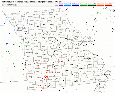
Flooding Rain Today
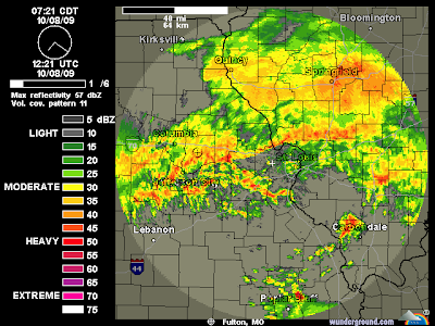
Heavy rain has been affecting the area since late last night. I don't know what your favorite sound is, but mine is thunder in the morning. It can perk me up better than a finely brewed cup of coffee. This rain has come so quickly, and our ground was semi-saturated from the wet end of September and early October. Creeks and rivers have quickly filled their banks. The road by our house had 3-4" of water over it, and in the 6 years we have lived here, I have never seen it with water.
Morning observations (as of 5:30 a.m.)
Fulton Station (MO-CW-1): 1.59"
Auxvasse Station (MO-CW-5): 2.85"
I've been hearing word of students not able to come to school and some roads have been closed in the area.
Here are some local storm reports. I'll update as I get time today:
6:30 a.m. (Boone County) Several water rescues have occurred
6:55 a.m. (Callaway County) 6-8" of water on county roads
::Update::
So far at school (using an electronic rain gauge) we have experienced 4.25". I haven't checked my CoCoRaHS gauge yet, so I'm looking forward to seeing if the electronic gauge holds up.
Other reports:
3.82" reported at Sanborn Field at the MU Campus in Columbia
2.25" in Mexico, just north of here

Tuesday, October 6, 2009
Rain Intensity Table
I was doing some research on the water cycle for a class when I ran across this table on the USDA website. It quantitatively defines precipitation of different intensities, and I found it to be interesting.

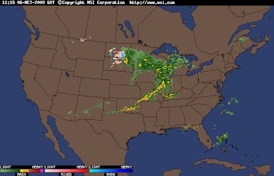
An early October cold front gave me a nice wake up this morning at around 5:00. Lots of lightning and 0.35" of rain fell (as of 6:00) in response to the squall line. The parent Low pressure center is currently marching into Wisconsin giving our friends up there another soaking, giving them a relief from a dry September.
The snow returns on the national radar is becoming more common each day. It won't be long!

Thursday, October 1, 2009
September Weather Summary / WY 08-09 Summary
I'm pulling double duty on this month's summary. With the books officially closed on the 08-09 water year, I'd like to share some water year data with you. First, let's start with this month.
As in my previous post, this month shows more of the same in the precipitation department. We ran another surplus, but only after following a 31-day period of 0.31". Late in the month, an upper level low spinning in Colorado offered us the relief we needed, and my lawn responded with vigor! Each mow, now I am thinking, "Is this the last time?" Let's hope this weekend is the last.
Overnight, a warm front lifted NE through the area, giving us a milder start to the day than the previous few mornings (temps in the 60s rather than 40s), currently, there is a wide swath of rain and storms spreading from Texas to Missouri, and into Montana. Quite impressive indeed. There is thunder in the area, and we are sure to get the first precip of WY 09-10.
September Observations can be found here
Temperatures
 September offered us very comfortable temperatures. We started and ended the month a bit on the cool side, but we stayed around average through the middle of the month.
High: 83° on 9/11 and 9/27
Low: 44° on 9/29 and 9/30
Mean High (average): 76.2° (79.1°)
Mean Low (average): 57.0° (55.4°)
# of Days Above Average High: 6
# of Days Below Average High: 20
Precipitation
Average Precip: 3.68"
September Precip: 4.28"
 And our yearly totals so far...
2007 - 2009 September Comparisons


In a comparison to the previous two years, you can see a remarkable difference in rain amounts. Last year, the tropics were extremely active, and we had two tropical depressions impact our area. One even came right through Missouri! The result of that is easy to spot on the graph. 2007, on the other hand experienced some extreme drought (if you'll remember, that was the same year with the devastating Easter Freeze).
September Days with Thunder: 2
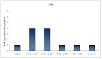
I took some time over the weekend to generate some disaggregated data concerning rainfall amounts. I was interested to know the frequencies in which we experienced heavy/light rainfall events. I'm excited to have these data now. Thanks to OSNW3 for showing me some cool features on Excel.
 January - August 2009
Days With Precipitation



Water Year 2008 - 09 Summary

Yearly Precipitation Average: 41.22"
WY 2008-09 Deviation: +6.00"
 Links to Monthly Summaries:
January
February
March
April
May
June
July
August
As in my previous post, this month shows more of the same in the precipitation department. We ran another surplus, but only after following a 31-day period of 0.31". Late in the month, an upper level low spinning in Colorado offered us the relief we needed, and my lawn responded with vigor! Each mow, now I am thinking, "Is this the last time?" Let's hope this weekend is the last.
Overnight, a warm front lifted NE through the area, giving us a milder start to the day than the previous few mornings (temps in the 60s rather than 40s), currently, there is a wide swath of rain and storms spreading from Texas to Missouri, and into Montana. Quite impressive indeed. There is thunder in the area, and we are sure to get the first precip of WY 09-10.
September Observations can be found here
Temperatures
High: 83° on 9/11 and 9/27
Low: 44° on 9/29 and 9/30
Mean High (average): 76.2° (79.1°)
Mean Low (average): 57.0° (55.4°)
# of Days Above Average High: 6
# of Days Below Average High: 20
Precipitation
Average Precip: 3.68"
September Precip: 4.28"
2007 - 2009 September Comparisons
In a comparison to the previous two years, you can see a remarkable difference in rain amounts. Last year, the tropics were extremely active, and we had two tropical depressions impact our area. One even came right through Missouri! The result of that is easy to spot on the graph. 2007, on the other hand experienced some extreme drought (if you'll remember, that was the same year with the devastating Easter Freeze).
September Days with Thunder: 2
I took some time over the weekend to generate some disaggregated data concerning rainfall amounts. I was interested to know the frequencies in which we experienced heavy/light rainfall events. I'm excited to have these data now. Thanks to OSNW3 for showing me some cool features on Excel.
Days With Precipitation
Water Year 2008 - 09 Summary
Yearly Precipitation Average: 41.22"
WY 2008-09 Deviation: +6.00"
January
February
March
April
May
June
July
August
Subscribe to:
Posts (Atom)


