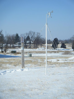
It has been a very dry January. For most of the month a northwest flow brought us cooler temperatures, one arctic outbreak, and dismal amounts of precipitation.
Total Precip: 0.27"
Snowfall: 2.4"
Days with Measurable Precipitation: 5
Days with Measureable Snowfall: 5
Days with Snow on Ground: 8
A Comparison To Last Year:
Total Precip: 2.13"
Snowfall: 0.1"
Days with Measurable Precipitation: 5
Days with Measureable Snowfall: 1
Days with Snow on Ground: 1
Saturday, January 31, 2009
Wednesday, January 28, 2009
Storm Links/Photos
- Photos from NWS in Paducah, KY office.
- St. Louis, MO Office Storm Summary (Includes a nice satellite photo of snow cover)
- Springfield, MO Office Storm Summary
- Memphis, TN Office Storm Reports and Photos
Some reports out of the Memphis office are amazing. If you have the time, read a few of them. There are some reports of an estimated 2" of ice. It's no wonder the damage there looks like a tornado went through.
My sister, Ami in Steelville sent me some photos of the snow at her house:
Storm Recap
What a storm. Even though we didn't receive much in the way of accumulation, it has been interesting to watch this one pan out. I look forward to studying this one in more detail when I get the time.
At this station:
New Snow: 1.4"
New Snow SWE: 0.21"
Storm Total: 1.8"
Storm Total SWE: 0.26"
At this station:
New Snow: 1.4"
New Snow SWE: 0.21"
Storm Total: 1.8"
Storm Total SWE: 0.26"
The NWS St. Louis office has released storm totals:
View it HERE
Here is a picture from the back yard.
Ami,
It looks like Steelville officially received 3.3" of sleet/snow. I'm sure it's beautiful down there. Send me some pictures if you can and I'll post them on here.
Tuesday, January 27, 2009
Tuesday Night Storm Update
Quick recap on today's snow:
Early this morning, a very thin band of moderate snow moved through the area and dropped 0.5" on us (in my previous post, I estimated 1").
It stayed dry for the most part until just before 7:00 a.m. when a small area of light to moderate snow marched overhead. That was the catalyst that caused a flurry of superintendents calling off school in the area. (I was already at school when I got the call)
Through the mid-day hours, light flurry activity dominated the sky. After noon, the activity increased to light/moderate rates. This continued until just now, when as of this post the snow is coming to an end. I expect this to be the storm total, although I will wait until my scheduled 7:00 a.m. reporting time tomorrow morning. Storm total stands at 1.2" at this station.
I got my inch!
Local storm reports are showing much more impressive amounts to the south and east of this location. Many areas have been receiving heavy sleet for hours, and are just now getting a layer of snow on top of that. My Mom reported to me this morning in Rolla that Monday night's sleet layer has an icy crust on the top. They sure have a mess down there.
Here's a graphic of the sleet that accumulated south of here yesterday. Their totals are higher tonight. I'm looking forward to getting a full recap from the NWS offices.
Much of the snow we have received have been needle-shaped. I would like to one day study the formation of snow, and what atmospheric conditions are needed to produce the different shapes.
Monday, January 26, 2009
Snow Storm Update
So far, this storm has been anything but impressive in Mid-Missouri. This is where I wish I had a meteorology degree, so I could figure out just what is happening. My best guess is that one of two scenarios are occurring: Either the track of the low has taken a more southerly turn, or drier air has advected into our region. Whatever the cause, the effect is the same.
It has been cold and cloudy all day. Some light frz rain/sleet began to fall at 4:30 p.m. and lasted for about 45 minutes, leaving another dusting on the ground. Nothing has happened since...here at least. Looking further south paints a much different picture.
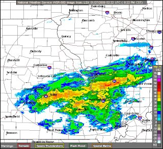
Much of my family is in the Rolla/Steelville area, and they are getting battered with moderate to heavy sleet at this time. My sister in Steelville reported to me that she has an estimated 1/2" of sleet on the ground currently. With the forecast of a couple more hours of sleet and ice, followed by some heavy snow, it's possible that they might end up with quite a mess tomorrow morning. Schools there have already been cancelled. (I'm still holding out hope for me, I need some time to grade some tests)
I am beginning to notice what may end up being a characteristic to remember about this storm. The general NE flow of the precip is setting up the stage for some very steep snowfall amount gradients.
From the St. Louis NWS discussion: THE MOST UNCERTAINTY DEALS WITH HOW FAR NORTH TO TAKE THE MODERATE TO HEAVY ACCUMULATIONS OF SLEET AND SNOW. THIS COULD VERY WELL BE THE SITUATION WHERE THE NORTHERN PART OF THE ST. LOUIS METRO AREA ONLY RECEIVES A COUPLE INCHES OF SNOW...BUT JEFFERSON AND MONROE COUNTIES RECEIVE 6+ INCHES OF SNOW AND SLEET. THIS DEMARCATION LINE COULD END UP BEING A COUPLE OF COUNTIES NORTH OR SOUTH OF CURRENT FORECAST.
This reminds me of a wild snow event that occured in Southwest to East Missouri in March of 2008, where the difference of 20 miles meant the difference of 10" of snow in places. Check out the storm summary:
In East Missouri:

In Southwest Missouri:

Follwing the strip from bottom left to top right (Cassville to Jefferson City) was an area of 4"-8" of snow, while the adjacent areas had <1".
Tonight, some areas in SE Missouri are under the gun to receive up to and exceeding 1" of ice. I certainly hope that doesn't pan out for them, as I know how crippling that could be for many.
It has been cold and cloudy all day. Some light frz rain/sleet began to fall at 4:30 p.m. and lasted for about 45 minutes, leaving another dusting on the ground. Nothing has happened since...here at least. Looking further south paints a much different picture.

Much of my family is in the Rolla/Steelville area, and they are getting battered with moderate to heavy sleet at this time. My sister in Steelville reported to me that she has an estimated 1/2" of sleet on the ground currently. With the forecast of a couple more hours of sleet and ice, followed by some heavy snow, it's possible that they might end up with quite a mess tomorrow morning. Schools there have already been cancelled. (I'm still holding out hope for me, I need some time to grade some tests)
I am beginning to notice what may end up being a characteristic to remember about this storm. The general NE flow of the precip is setting up the stage for some very steep snowfall amount gradients.
From the St. Louis NWS discussion: THE MOST UNCERTAINTY DEALS WITH HOW FAR NORTH TO TAKE THE MODERATE TO HEAVY ACCUMULATIONS OF SLEET AND SNOW. THIS COULD VERY WELL BE THE SITUATION WHERE THE NORTHERN PART OF THE ST. LOUIS METRO AREA ONLY RECEIVES A COUPLE INCHES OF SNOW...BUT JEFFERSON AND MONROE COUNTIES RECEIVE 6+ INCHES OF SNOW AND SLEET. THIS DEMARCATION LINE COULD END UP BEING A COUPLE OF COUNTIES NORTH OR SOUTH OF CURRENT FORECAST.
This reminds me of a wild snow event that occured in Southwest to East Missouri in March of 2008, where the difference of 20 miles meant the difference of 10" of snow in places. Check out the storm summary:
In East Missouri:

In Southwest Missouri:

Follwing the strip from bottom left to top right (Cassville to Jefferson City) was an area of 4"-8" of snow, while the adjacent areas had <1".
Tonight, some areas in SE Missouri are under the gun to receive up to and exceeding 1" of ice. I certainly hope that doesn't pan out for them, as I know how crippling that could be for many.
Sunday, January 25, 2009
Round One Over, More Snow Expected
Snow began to fall this morning around 5:30, and by daybreak it was accumulating somewhat on the roads/sidewalks around the house. It was a very grainy snow, with some dendritic flakes mixed in. By mid-day, the snowfall had subsided, leaving 0.25" on the snow board. Normally that wouldn't excite me much, but I know more is on the way.
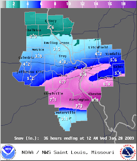
Tomorrow afternoon, snow is expected to spread from west to east and overtake much of Missouri due to an approaching trough. Column will be cold enough for an all snow event here in Fulton, but points south and east of here (especially in the bootheel area) may get significant icing up to 3/4".
Snow Forecast From the NWS Office in St. Louis

An update tomorrow...
Saturday, January 24, 2009
A welcomed change in the weather pattern
I don't have much time to write about this weather system today, but it is getting me excited for next week. Here is what the NWS office in STL has to say about it:
...WINTER STORM POSSIBLE NEXT WEEK...
AN ARCTIC HIGH PRESSURE SYSTEM WILL LOCK A SUBFREEZING AIRMASS OVER THEBI-STATE AREA THIS WEEKEND...AND THESE COLD TEMPERATURES WILLPERSIST THROUGH THE MIDDLE OF NEXT WEEK. SOUTHERLY FLOW FROM THEGULF OF MEXICO WILL DEVELOP ON MONDAY NIGHT IN RESPONSE TO AWEATHER SYSTEM THAT WILL MOVE FROM THE DESERT SOUTHWEST INTO THEMIDWEST DURING THE MIDDLE OF THE WEEK. MOISTURE FROM THE GULF OFMEXICO WILL BE PUSHED INTO THE VERY COLD AIRMASS OVER THE BI-STATEREGION BY THIS SOUTHERLY FLOW. SNOW...SLEET...AND FREEZING RAINARE LIKELY ACROSS THE REGION...AND THERE IS THE POTENTIAL FORSIGNIFICANT ICE AND SNOW ACCUMULATIONS ON MONDAY NIGHT ANDTUESDAY...POSSIBLY CONTINUING FURTHER INTO THE WEEK.
Since this system is still in the Pacific Ocean, there is still some uncertainty as to the track/speed/strength of the storm. It is worth watching, and I'll post more as the system gets closer.
Saturday, January 17, 2009
Dry and Cold January
Not much to say about this January's weather. Dry and Cold is the best way to describe it.
So far at this station, we have received some dustings of snow, with the heaviest snowfall happening yesterday with a whopping 0.2" of powdery snow on the ground. Total precipitation for January so far has been dismal as well, only totaling 0.11" at this station, and 0.02" at MO-CW-5 in Auxvasse.
The big story has been the bitter arctic air mass that invaded the midwest Wednesday - Thursday.
Here's a rundown of the temperatures we have experienced so far:
1/1 --- 44/18
1/2 --- 47/27
1/3 --- 68/39
1/4 --- 40/20
1/5 --- 30/17
1/6 --- 34/26
1/7 --- 38/29
1/8 --- 34/16
1/9 --- 64/28
1/10 --- 35/17
1/11 --- 42/15
1/12 --- 48/22
1/13 --- 25/8
1/14 --- 38/3
1/15 --- 10/-5
1/16 --- 14/-3
Subscribe to:
Posts (Atom)
