Thursday, December 16, 2010

Cold Start to December / Dec 16 Ice

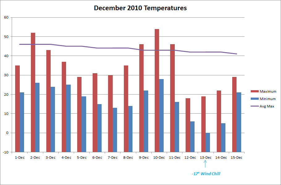
We have experienced a colder than normal start to the month with a mean temperature of 26.0°, a -8.2° departure for the period of Dec. 1-15.  As seen from the chart below temperatures have been below average, but of note are two periods of cold (4-8) and (12-15).  Both brought breezy canadian air with it, and the latter gave us our 2" mini-blizzard on the 11th and 12th. 


Ice Dec. 15-16

An upper-level disturbance is bringing snow to the upper plains and through to the east coast.  As it developed, it brought light freezing drizzle/rain to our area.  Barely enough to measure in the rain gauge, but it was enough to create a thin glaze on roads and elevated surfaces (enough to call off schools even).  Below is this morning's radar showing the long band of snow affecting the nation.


Sunday, December 12, 2010

Dec. 11-12 Winter Storm

(Source:  NWS STL)


Update 8:00 a.m.

The snow ended early this morning and the wind didn't let up a bit all night.  With gusts sustaining in the upper 30 mph range, it made for some difficult snow measurements this morning.  I made multiple measurements around the yard, and came up with a 2.0" total.  This storm reminds me of the January 6-7, 2010 storm.  Strong NW winds made similar drifting patterns, although more exaggerated due to double the amount of snow then.  Pictures from that storm can be found here.  Compare those with this year's storm.

Here are a couple of pictures from the storm:


Update 12:00 a.m.

Snow is currently falling with vigor in Missouri again.  After much anticipation, we will reach our first inch tonight.  We reached our maximum temperature of 46° around 10:00 am, and by 10:00 pm we were at 17°.  Morning rain changed to a mist, and then quit for a while.  Around 2:00 we started seeing flurries flying around, which intensified bit by bit through the evening hours.  Tonight, at 12:00 am snow is falling at a moderate rate and wind gusts are reaching 40 mph.  The current temp is 16°.

I tried to make a measurement, and my best estimation is a current depth of 0.5".  Below is a video I shot and the coinciding radar image at 11:45 pm.


Tuesday, December 7, 2010

November Weather Summary

The dry weather continues this month.  After an extremely arid 0.54" total for October, we ended up with a slightly better 1.74" for the month of November.  The dry months stick out to us lately, since we haven't really experienced any prolonged stretches of dry weather patterns in the past three years.  I did a quick data check.  Over the past 36 months, 27 of them have exceeded the normal precip amounts, and only 9 have had deficits.  The months with deficits, ranging from 1/2008 - 11/2010 are:

Aug 08
Nov 08
Jan 09
Nov 09
Mar 10
May 10
Jun 10
Oct 10
Nov 10

It's interesting to note that the past three Novembers have run on the low side of precipitation.


Temperature


Mean Temp: 45.9°
Deviation: 2.7°
Maximum:  75° on Nov. 10
Minimum:  18° on Nov. 26

Precipitation


Average November:  3.85"
Actual November:  1.74" (-2.11")

Days with measurable precip:  7

Snow

We did see our first flakes of the year on the 30th.  Some midday flurries and light snow just blew around, but made for a welcomed sight for me.  It's hard for me to imagine, but our average snowfall for November is 1.6"

Other Weather Info:

Days with thunder:  2
Days with fog:  1
Days with wind gust (>= 20 mph):  20

Friday, December 3, 2010

Tuesday, November 30, 2010

First Flakes of the 2010-11 Season!

At 11:00 a.m. today the alarm went off.  20 pre-teen students went nuts at the sight of our first flakes falling from the sky.  All learning ceased for a good 5 minutes as they postulated the probability of getting out early as their calm (but equally as excited) teacher tried to explain how the dynamics of the storm wouldn't allow for much snow to fall...but to no avail. 

A strong storm system to our north brought us a relatively dry cold front.  With it came a steep decrease in temperature, and sharp gusty winds from the NW.  We got some good flurries and a light snow shower between 11:00 and 11:45 am.

Wednesday, November 24, 2010

Winter Storms

The dry weather pattern that has dominated our region for the past 60 days is beginning to ease up.  After 56 days of only 0.99" of precip, we have enjoyed three days in a row with rainfall, and two of them graced us with thunderstorms. 

On Monday, you could feel the moisture in the air all day as a strong southerly WAA was in effect.  The trailing cold front brought some strong storms to the area.  In Auxvausse, the rain and wind was pretty intense, but at home I only found 0.06 in the gauge.  Our wind topped 40 mph with the strongest storm.

This morning, we have had steady light to moderate rain with embedded storms, although not as strong as Monday's.  The main feature of these storms is heavy rain.  We have ponding in our back yard this morning, not because of large amounts of rain, but rather because of our extremely dry semi-impermeable clay soil.

Awaiting a strong cold front tonight.  Should be a brisk day tomorrow!

Wednesday, November 10, 2010

Dry and Pleasant Start to November

So far, the November weather pattern has followed suit with what we've been experiencing the past month and change.  We are on day 16 with no rainfall, and of the past 46 days, only 0.54" of rain has fallen.  We haven't experienced this type of aridness since the summer of 2007.  There are currently no immediate impacts that I can forsee of our lack of moisture.  There are places in Missouri, however that are drier than us and are in need of groundwater recharge.

Oh, but the changes are a comin.  With the passage of a weak cold front tonight, the cards are set for a colder and more active weather pattern.  High temperatures will most likely stay at or below normal for most of the rest of the month, and we may even see our first flakes of the year.

Diurnal Temperature Variations

Thanks to a comment on Bob's blog, posted by OSNW3, I was curious to know what our diurnal temps do throughout the year.  I must admit, I never thought of it before.  Interesting stuff indeed.  Here's what I found out.


As expected, the transitional months of Mar/Apr, and Sep/Oct contain the highest amount, with the more steady temperatures occurring in the summer and winter months.  In winter, we can see days where the temperature doesn't move but a few degrees in a 24 hour period.  The dense air masses that invade the area, and prevalent cloud cover throughout no doubt have an impact on this.  I was a bit surprised with November, as there's a pretty extreme drop off from the beginning to the end of the month.  I'm sure the increase in cloud cover that occurs during this  month has a part in this equation as well.  Lots to think about on this one!