Saturday, November 6, 2010

October Weather Summary

What a change we experienced this month!  A quick look at our data throughout the year, and October will stick out.  Dry and warmer-than-average is the best way to summarize the month.  We have had only 0.54" recorded over the past 41 days, and 71% of those days recorded higher than average max temps.  The dry and warm weather couldn't have come at a better time, as the regional farmers were given ample time to get in their crops.  Most are done now, and have started in on their winter work.

We had our first frost on Oct. 4th
Our first freeze occurred on Oct. 29


Temperature

The above average temperatures were incredible.  It gave us a longer than normal transition period between summer and winter.  Usually in this region we get about 10 days of "chamber of commerce weather" before cold/windy days arrive. 


Mean Temp:  59.5°
Deviation:  3.4°
Maximum:  85° on 8-Oct
Minimum:  28° on 29-Oct

Precipitation

Not much happening here.  As you can see in the graphic below, much of the country had dry rain buckets, with extremes in SE Texas and Florida.

(Source: water.weather.gov)


Average October:  3.25"
Actual October:  0.54"  (-2.71")

Days with measurable precipitation:  4


Check out the contrast between last year and this year.

Other Weather Info:

Days with thunder:  1
Days with fog:  4
Days with wind gust (>= 20 mph):  16

A final count on mowing the yard:  22.  Kids in the neighborhood here charge ~$20 per yard.  That's a pretty good haul for a teenager, especially if you have the time to work several houses through the summer.

Thursday, October 28, 2010

First Freeze 2010 / YouTube Channel

It seems that our first freeze will occur tonight and tomorrow morning.  The historic cyclone that set records and wreaked havoc for much of the country also brought with it some cold, dense air.  The ridge of high pressure, coupled with a light wind will provide us with our first freeze of the year.


Wxwtchr YouTube Channel now online!

Thanks to OSNW3 and Bob for the idea, I started a channel for this station in Fulton.  I posted a video tonight (the rest are on my work computer).  But now that we have an upgraded system at home, you can expect much more to come! 

Monday, October 25, 2010

Sounds and Smells of Spring

You know the smell I'm talking about.  The moist, complex smell that is so prevalent in April and May.  Birds are singing their encouraging melodies, dew points are in the 60s, and storm spotters are put on alert.

The past couple of days have been very spring-like.  Saturday, St. Louis recorded a record high low temperature of 67 degrees (2 degrees above the normal high).  Hail reports clogged the NWS phone lines last night as a line of storms invaded the I-44 corridor from Rolla, MO to Illinois.


Stormy Night

It's not often we see these icons on our forecast page, let alone at the end of October.  Although a severe event is not out of the question any given year, it certainly does catch you by surprise. 

A powerful cold front is driving through Missouri tonight, bringing with it a squall line with embedded mesocyclones that are likely to produce some tornadoes (according to the latest evening HWO discussion).  The quick pace of the front and resulting speed of the storms adds a higher degree of urgency if storms do turn severe.

As of 10:05 p.m., the squall line had started to develop, as seen here in the watch product.  A very large area is under the gun until 6:00 a.m.

Wednesday, October 20, 2010

October Lull

This October is proving to be a very dry one, indeed.  We haven't been impacted with any notable weather system the entire month.  It has resulted in a beautiful month with plentiful sunshine.  The Indian Summer ended, and we are back to normal temps now.  For the 20 days so far this month, we have had 1 day of measurable precipitation, which brings our monthly rain total to 0.07".  A far cry from last year's October total of 12.49" (18 days of measurable precip). 

Unsettled weather is expected to join us again for the last week of the month.  Depending on the strength of the systems, it could still pull us up close to our average for the month.

Tuesday, October 12, 2010

Indian Summer Coming to and End

Although I can't find specific thresholds defining the beginning and end of an Indian Summer, I can say with confidence that our current warm period is coming to an end.  After our first frost on Oct. 4th, and another frost on the 5th, our skies cleared and temperatures stayed well above normal for a 6 day period.  High pressure settled in the mid-section of the nation, keeping millions high and dry for the beginning of October. 

A strong system from the NW has finally provided enough kick to move that airmass out of the area, and we are experiencing more seasonal cloudy, rainy, and normal temperatures for the mid-section of the week.  

Thursday, October 7, 2010

September Weather Summary


Well, this September symbolized all I love about the fall in Missouri.  We experienced strong thunderstorms, heavy precipitation, plenty of windy days (1 out of 3 days had wind gusts >= 20 mph), and a nice cool-down that brought air as fresh and crisp as the ripe Missouri apples we've been enjoying.

An interesting fact about this September.  On Sep. 19, we had a 1.18" rain that put us just over our yearly average of 41.22".  Every drop of rain from here out is a surplus, which has been the norm since 2008.  Last year, we hit our average yearly precip total on October 7.


Year / Amount Surplus

2008:  18.66"
2009:  17.00"
2010:  2.15" (as of 9/30)


Temperatures

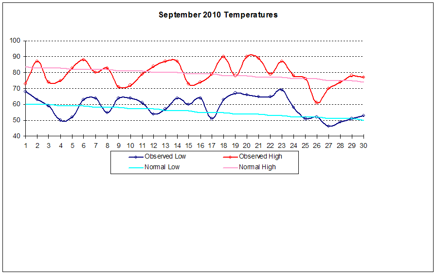
It really was a tale of two seasons, and as I remarked in a previous post, the delineation between summer and fall was quite easy to notice, and can be seen on the graph below.  September 24 was a good "first fall" day (although I have no quantitative formula to back that up)


Mean Temp:  69.1°
Deviation:  +1.8°
Maximum:  90° on Sep. 18
Minimum:  46° on Sep. 27

Precipitation

Once again, we have been inundated with heavy precipitation.  Those living in flood plains have had a rough three years, and there were many farmers in the area that lost entire fields of crops due to a late-year flood right before harvest time.  


Average September:  3.68"
Actual September:  8.26"  (+4.58")

Days with measurable precipitation:  13


Other Weather Info:
Days with thunder:  4
Days with fog:  9
Days with wind gust (>=20 mph):  10


Yearly Totals:

Thunder:  44
Fog:  43
Wind Gust:  58
Mows:  20

Coming Soon...Water Year 2009-2010 Summary


Monday, October 4, 2010

First Frost of 2010

A cool Canadian high pressure system and a clear sky brought us our first frost over night.  At this station, we dropped to 36° around sunrise today (10/4).  Frost was fairly thick on the roof of my car and other elevated metallic surfaces.  I welcome the cool weather with open arms!