Wednesday, July 21, 2010

Severe Storm July 20

For the past three days, a line of strong and severe storms have raced through our area bringing with them very heavy rain, lots of lightning, and strong winds.  Sunday morning's storm brought with it some hail in addition.  We missed out on Monday's storm, but it knocked down a barn 20 miles north of us.  Tuesday's storm is the topic of this post.  The storm hit around 7:30 a.m. and had lots of lightning, and the strongest winds I've seen since my 6 years in Fulton.  Officially at this station, we recorded a NW wind at 48.3 mph.  Now the anemometer is in a somewhat sheltered area given the houses around us, so I would bump that speed up for accuracy.  After the initial storm passed, light rain fell for about 2.5 hours.  Rainfall totaled 1.02" for the morning.

At night, we had another storm roll through, bringing our daily total to 1.32"

Below are pictures of the damage to the neighborhood.  Anything that wasn't secured down was blown out of yards.  Multiple trees, up to 12" in diameter were snapped in half, and those folks with 6' privacy fencing lost sections.  The van across our street was damaged by a flying piece of fence.  The storm was apparently at its worse over southern Fulton (including my neighborhood).  Where I work, on the north side, we didn't have a single twig on the ground.  But as I drove home for lunch, I saw more and more limbs on the side of the road.


One of the damaged fences

Saturday, July 3, 2010

June Weather Summary

So far, I can say that the past few summers have just been plain nice in Missouri.  We are still experiencing days with dew points topping 70°, but temperatures haven't been that oppressive (which can be a typical talking point for Missouri loafers).  The last time we officially hit 100° was August 16, 2007 (according to the NWS Columbia Station).  I remember 2007 as an intense summer.  We had a string of 20 days at or above 90° (from 7/31 - 8/19), and if I remember right we had a minor to moderate drought in parts of Missouri.  I remember a funny scene on the news that summer.  The Governor was giving a speech at a Mid-Missouri farm announcing the release of state emergency funds for the drought...in the middle of a tropical downpour!

All that being said, we have enjoyed a couple of nice years, but the law of averages are not pointing in our favor.  And traditionally July and August are our toughest months.

Dew Point

I am interested in keeping track of the amount of moisture in the air throughout the year (by means of dew point temperature).  Although I could manually check the hi/low Td for each day as I do with the temperature, I'm not convinced I would stay disciplined enough to keep steady data (feeling overwhelmed as I do often).  For now, a glance of nighttime temps will suffice, as a lower Td will allow for more cooling overnight.  This month, we had 10 days with a nighttime low at or above 70°.  That makes for some sticky weather -- or "Air you can wear"-- as one local meteorologist puts it.


Temperature

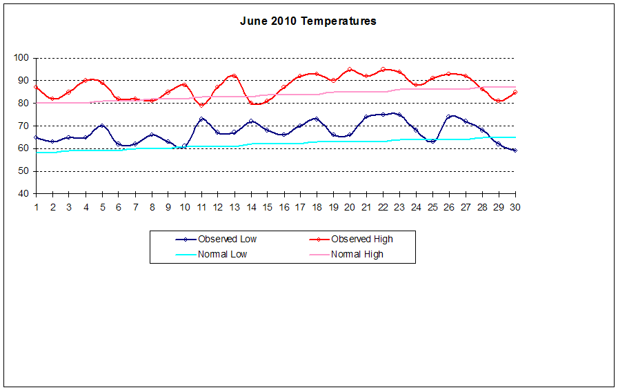
Mostly above average this month.  We had 23 days with a high exceeding the average, which helped bump up our mean temp quite a bit over the 30 year average.


Mean Temp:  77.4°
Deviation:  +4.7°
Maximum:  95° on Jun. 20
Minimum:  59° on Jun. 30

Precipitation

Interspersed as it was, we still didn't hit the mark this month.  Pop-up showers and thunderstorms were the norm in Missouri this month, so extreme differences can be found from station to station.  We weren't that lucky, although we did receive our fair share.  The lawn looks the brownest that it has in three years (which is its normal dormancy period for MO).  I don't mind much because it gives the mowing a little respite.


Average June:  3.87"
Actual June:  2.79"  (1.08)

Days with measurable precip:  12


Other Weather Info

Days with thunder = 7
Days with fog = 1
Days with wind gust (>= 20 mph) = 5

Our lawn mowing count is up to 10 for the year.  I'm still thinking the total might top out at around 18...we'll see.

Random Photos and Video

Below is a video I shot shortly after sundown on May 24. The lightning was simply beautiful that night, so I couldn't help getting video of it. The camera view is facing ESE.


Other photos I have are ones that I've snapped over the summer.  There are plenty, but I chose only a sampling.  Enjoy!


Sunrise - June 27, Montauk Springs


The garden so far. We've got peppers that are close to being ready,
lots of green tomatoes, and squash comin out of our ears!

Friday, June 11, 2010

June 8 Shelf Cloud

June has been relatively active for Missouri.  While we have experienced average precip here, the poor folks in northern MO have had an extremely wet 14 days.  Estimates for extreme northern MO are up to 10" according to the AHPS Precipitation Analysis team.

The purpose of this post, however is to share one of the most exciting clouds I've witnessed.  On the morning of June 8th, around 11:00 a.m., a rather large complex of storms eased its way southeast.  After hearing reports of a wicked shelf cloud 30 minutes ahead of the actual storm, I grabbed the camera and waited outside.  I was not disappointed!  I made an attemt (my first) at pasting together a panoramic of the clouds, but believe me the picture doesn't do the cloud justice.  This was amazing.


(For a larger view, click on the picture)

May Weather Summary

Since the last post, May dried off and heated up.  We enjoyed some sun at the beginning of the month, a wet--although not over the top--middle, and by the end, we were getting a nice welcome into summer.


Temperature


Mean Temp:  64.7°
Deviation:  +1.0°
Maximum:  91° on May 24
Minimum:  41° on May 8

Precipitation


Average May:  4.97"
Actual May:  4.23"  (0.74")

Days with measurable precip:  12


Even with 12 days of measurable precipitation, we still came under the mark for the month.  This is partly due to the fact that we didn't have any 1" events, but rather more moderate amounts as shown in the above graph.  Compare this with last year's totals below.  We had 12 days of measurable precip, but over an inch more rain filled the bucket.


Other Weather Info

Days with thunder:  10
Days with fog:  4
Days with wind gust (>= 20 mph):  5

As of today (June 11), we've mowed the yard 7 times.

Tuesday, May 18, 2010

A Soggy Eight Days

May has been tricky this year.  We started out with clear blue skies, and for the most part above average temperatures.  But the last eight days have been a much different story.  While it hasn't come in abundance each day, it has rained on and off - sometimes very heavy, sometimes just a steady mist.  But the fact remains that it has soaked us.  The eight day total is 3.45", which is 69% of our May average.

Some Mid-May Stats:
(May 1 - 17)

Mean Temp:  59° (2.6°)

Precip Total:  3.69"

Days With Thunder:  7
Days With Fog:  3
Days With Wind Gust (>= 20 mph):  5


As of today, I've mowed the lawn 4 times.  The chives are looking beautiful - I'll have pictures of them on my monthly summary.  Not a cloud in the sky today...I'm looking for some time to dry out!

Saturday, May 1, 2010

April Weather Summary

-----**  Additional Yearly Data Updated on 5/5/10 **-----

April in Missouri can be a wild time.  The transition between Winter and Summer can cause some intense battles between air masses, and the midwest is fortunate (or, depending on your view--unfortunate) to receive the brunt of these clashes.  While we did have a couple of very weak tornadoes in and around the area, there was no real severe weather to write home about.  April can be split up into three segments this year:  Wind, warmth, and water.

Wind

50% of the month could be classified as "breezy" (gusts =< 20 mph), as we experienced 15 days meeting that criteria.  The first 8 days of the month were incredibly breezy, as they finished off a 10-day period of windy weather.  The top wind gust of 40 mph occurred on April 23rd as a strong bow echo passed through.  You can view the data HERE.

Warmth

Take a look at the temperature graph.  You'll see that of the first 15 days, we experienced a high temperature below average only once.  The high temperature during those 15 days averaged at 77.5°, where the normal average high for that period was 63.6°, a 13.9° difference.  OSNW3 experienced the same warmth in Wisconsin.  For his perspective of April from the upper-midwest, click HERE.

Water

The last 10 days of the month experienced an active weather pattern that brought most of our monthly precip total.  Collectively, we recorded 2 days with precip above 1", with our one-day max occurring on the 24th of 3.02".  We exceeded our monthly average by 2.58".


Temperature


Mean Temp:  60.9°
Deviation:  +6.5°
Maximum:  87° on Apr. 1
Minimum:  36° on Apr. 9

Precipitation


Average April:  3.96"
Actual April:  6.54"  (+2.58")

Average April Snow:  0.6"
Actual April Snow:  0.0"  (0.6)

Days With Measurable Precip:  11


As the year goes on, count on seeing more bars on the heavy side of the graph.

To compare this April with the past two years:

Other Weather Info

Days With Thunder:  7
Days With Fog:  4
Days With Wind Gust (>= 20 mph):  15

Yearly Weather Info
With the year a quarter of the way done, here's some miscelaneous data:

Max Temp:  87° on Apr. 1
Min Temp:  -5° on Jan. 9

Greatest 1-day Precip:  3.02"  on Apr. 24
Greatest 1-day Snow:  5.4"  on Jan. 6


Days With Thunder:  11
Days With Fog:  21
Days With Wind Gust (>= 20 mph):  28 
# of Mows:  2

Monday, April 5, 2010

March Weather Summary

Another textbook month for Mid-Missouri.  March offered a nice respite from the usual suspects of winter by bringing more warmth, humidity, thunder, and more color to the area.  Old man winter seemed to get one more punch in on the 20th with a day filled with snow to our west and sleet in the Fulton/Jeff City area.  Other than that, it was a very nice spring-filled month.  Especially the last week.  OSNW3, it definitely went out like a lamb here, too.

March Daily Observations

Temperature

In typical March fashion, temperatures fluxuated (though not wildly) throughout the month.  The spread occurred from the beginning of the month to the end.


Mean Temp: 46.5°
Deviation:  2.4°
Maximum:  85° on Mar. 31
Minimum:  20 on Mar. 3

Precipitation

Average March:  3.14"
Actual March:  2.74"  (-0.40")

Average March Snow:  3.4"
Actual March Snow:  0.1"  (-3.3")

Days with Measurable Precip:  10
Days with Measurable Snow:  1
Days with Snow Cover (>0.1"):  1


Days with Precip:


Average Monthly Total:  3.14"

As you can see, we haven't hit our 3.4" of snow mark, nor gotten even close to it for three years now.  Spring has been coming early for us. 


Other Weather Info

Days With Thunder:  2
Days With Fog:  4
Days with wind gust (>= 20 mph):  3