Wednesday, June 17, 2009

Big Storm...Close Call

Numerous reports of rotation and a wall cloud were coming out of the storm that hit the Fulton area tonight. We hit a high temperature of 96 today and I recorded a max dew point temp of 78! By around 4:00 p.m., I could see the signature cirrus clouds being blown our direction indicating a large storm brewing to our NW. Surely enough, a HUGE supercell had formed in Northwest Missouri, and was kicking up severe storm warnings with large hail reports.

Before long, another cell formed in northern Boone county and quickly intensified. It had a path headed straight for us, and the clouds ahead of the storm were simply amazing. Here is a shot I took, looking almost due West of the southern part of this storm:


What a beautiful storm it was.

Not long after this picture was taken, as the storm was approaching, reports began to come in of a wall cloud being spotted. As soon as that was reported, the sirens went off. So off to the tornado shelter we went (our neighbors across the street -- we don't have a basement!). The lightning was INTENSE! I wouldn't be surprised if two bolts of lightning hit our subdivision.

At 8:01 p.m., hail began to fall. It was very intermittent, and started as pea to penny sized. After a couple of minutes, the hail grew in size to a max of 1.25" (est).


This picture was taken about 10 minutes after it fell (I waited until the lightning was far enough away), so I'm sure it was a little larger when it fell.

A weather spotter saw a well defined funnel cloud to the north of Fulton, but to my knowledge, no tornadoes were spotted.

After this storm passed, the big supercell that was trailing it broke up, going to our north and to our south.

New Cloud Type; June 14-16 Rainfall

Have you seen the news? It seems that some wild clouds are capturing the attention of some people. This new cloud type, the Asperatus, may be the newest classification of clouds added into the World Meteorological Organization's International Cloud Atlas since 1951. What's weird to me is that I think I've seen these before. I can remember my first year of college, looking out my dorm window viewing some wicked clouds that seemed to wave at the base...looked like some of the pictures on the news.


Read more here


The National Weather Service in St. Louis posted a breif summary of some rain totals in the area from June 14 - 16. The map shows data from both CoCoRaHS observers and ASOS/AWOS stations.


Map from NWS STL

Check out some of the totals. At this station, we had 2.48", but 13 miles north of us in Auxvasse, there was a reported 6.00"!!


Sunday, June 14, 2009

Heavy Rain Expected!


The 1-3 Day Quantitative Precipitation Forecast says it all for the next three days. Several rounds of thunderstorms are expected through Tuesday bringing with it the threat of heavy rain and some strong to severe storms.

Currently, at the mid-month point, we are sitting at 2.44". With a monthly average of 3.87", we may end up with a surplus this month. I don't mind much because it helps with the water bill, but this area has been hit with some moderate flooding this year, and some flood plains could use a rest I'm sure.

I'll update with any storm/heavy rain reports as they happen.

Tuesday, June 9, 2009

Hail Pad Image

Here are three images of the hail pad from yesterday's storm. I didn't notice it before, but when I went out yesterday to retreive it, I noticed that some of my tomato plants suffered some damage from the storm. One plant was split in half (presumably by a hail stone)!


Monday, June 8, 2009

June 8 Morning Storm

I was surprised to see some yellow on the radar when I got up this morning at 4:30. A large cell was marching ENE across the middle of the state at a quick pace. Some minor hail was expected and brief heavy rain.

The storm sped up as it approached our area, and finally hit at 5:30 a.m. We had moderate rain and light wind at the beginning, but then the wind picked up to a recorded gust of 24 mph, and we had hail between 1/4" and 1/2" slamming into the house for about a minute. (Luckily the girls didn't wake up!). I put on my spotter hat and called it in, as well as our rainfall amount. In a period of 30 minutes, we received 1.15" of rain.

I will take a picture of the hail pad and post it soon.

Active weather week ahead!

Tuesday, June 2, 2009

Shelf Cloud ; Station Comparison Data

Thunderstorms erupted ahead of a cold front this evening bringing some intense rain to parts of Mid-Missouri. We had partly sunny skies all day, with clouds building more and more as the day progressed. By 5:30 p.m., I could start to hear thunder in the area. We experienced a storm approaching from the SW at 6:00 p.m. As it was approaching, I was able to snap a shot of the accompanying shelf cloud as seen here.

This storm brought a little lightning, and brief heavy rain. We ended up receiving 0.29" in 20 minutes. Columbia reported heavy rain to the tune of one inch in just 30 minutes. They are 20 miles from us.

The storm that passed quickly cooled us off. Tomorrow's high temps shouldn't reach 70. Gotta love Missouri.

More storms and showers expected tonight. There is the threat for these storms to set up in the same area all night bringing with it some flooding. Some areas may have 2-3" when the low pressure system makes its farewell late tomorrow.


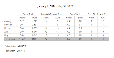
MO-CW-1 (Fulton) : MO-PH-5 (Rolla) -- A Comparison

My Dad joined CoCoRaHS in March, 2008. Since then I've had the pleasure of comparing precipitation data between us. Tonight, I filed through both of our reports since January 1 of this year, using categories submitted in my yearly Water Year Report.

Station Locations:


Stations are roughly 65 miles apart


On first glance, it's easy to note that MO-PH-5 has caught around 3.5" more than we have. You can also conclude that they experienced measurable precipitation 1 out of every 3 days. While the snow data does not summarize total snowfall for the season, you can see that MO-PH-5 received considerably more snow than we did...even though we had more "snow" events. I credit that to more available moisture where they are.