Sunday, December 28, 2008

Friday and Saturday's Weather

Well, we didn't receive the 3+" of rain that was expected, luckily. However, some of the more notable characteristics of this storm included mild temperatures for two days, and very high dew point temperatures on Saturday before the cold front moved through.


On Friday, the cold and associated surface low was located in KS/NE, and with abundant gulf moisture in place, we were expected to have some pre-frontal precipitation in the form of heavy rain and storms train over the area for a few hours. The pre-frontal precip did form, but in very thin bands in western/northwestern Missouri. These dissipated overnight, and we didn't get a drop, which took our QPF down considerably.


Friday night and Saturday felt like a typical spring day with stormy weather coming. It was almost eerie. Our dew point temperature officially hit 60° at Columbia Regional Airport in the morning hours of Saturday.


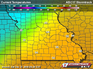
Here was a snapshot of the dewpoint temperatures at around 10:00 a.m.


...and the air temperature at that same time.


The front was at our doorstep by 10:10 a.m. as you can see in the radar graphic. The line of storms you see stretched from Mexico to Canada...truly a battlezone of airmasses.


A tornado warning was issued for Callaway county by 10:30 a.m. due to radar-indicated rotation, but no damage was reported in our county. There were two tornadoes reported just north of us in Audrain county, one of which destroyed a hangar and spread the debris 100 ft.


The storm dumped approx. 1.15" at this station.
Friday, December 26, 2008

Ice, 60 degrees, Chance of Tornadoes, Flash Flood Watch

Freezing Rain

This pretty much describes Missouri weather. On Tuesday, the 23rd, we received freezing rain, which changed over to rain through the day due to a lifting warm front. Before the glaze melted, there was an estimated 0.10" of ice on surfaces, and our sidewalks and roads were very slick. By night, the roads had cleared enough for all the holiday travelers.


Warm Temperatures

This morning, it is 50° with a stiff South wind bringing with it some abundant Gulf moisture and warm temperatures. We are forecasted to have highs in the mid 60s with heavy rain and strong/severe storms.


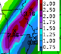
Here is the NWS HPC 1-2 Day QPF for today and tomorrow:


(Image Courtesy: NOAA)

Because of the frozen ground and high amount of rain that is expected in the area, the National Weather Service has issued a Flash Flood Watch from this evening into tomorrow afternoon.

The convective outlook on the SPC page is reminiscent of spring time weather, showing a decent probability of tornadoes and hail for the extreme southwest corner of Missouri extending up I-44 to about Rolla. Storms are expected to become strongest late overnight.

Tornadoes are not that uncommon in the winter. Last year, on January 7 there was a tornado outbreak across Oklahoma, Missouri, and Illinois. The STL NWS office has a great overview of this outbreak.

Check it out Here

Monday, December 22, 2008

B-R-R-R-R-R-R-R

Cold.


While not at record levels, it is just cold out this morning. Currently the temperature is sitting at 0°, with a wind chill of -10°. Makes me very thankful for a warm house, a car that works, and a garage to keep it in! How blessed we are.


Mixed bag of precip headed our way. We should see everything except hail during the next 48 hrs. I'll report back then.

Friday, December 19, 2008

Record Setting Year

We had our 4th snow day this week, and when I climbed into my car to head to work, it was 50° and roads were clear. The deal was that the gravel roads that criss-cross the school district were a sheet of ice after the fz ra followed by more rain overnight...and you won't hear me complaining. I got some quality time with my family.

I stumbled across this interesting bit of information from the NWS STL office:

St. Louis Yearly Precipitation Record Within A Few Hundredths

ST. LOUIS (1870-2008)
TOP TEN WETTEST YEARS ON RECORD
1. 54.97 (1982)
2. 54.94 (2008)
3. 54.76 (1993)
4. 51.65 (1984)
5. 50.83 (1927)
6. 50.73 (1985)
7. 50.31 (1946)
8. 49.28 (1915)
9. 49.20 (1898)
10. 48.46 (1876)

COLUMBIA (1890-2008)
TOP TEN WETTEST YEARS ON RECORD
1. 62.49 (1993)
2. 55.43 (2008)
3. 55.37 (1985)
4. 54.62 (1892)
5. 53.62 (1990)
6. 50.70 (1984)
7. 50.50 (1973)
8 50.34 (1969)
9. 49.70 (1927)
10. 48.53 (1981)

(Through 4 am Friday December 19th 2008)

At this station, we currently have 58.22" recorded for 2008


VERY COOL GRAPHIC


On the NWS EAX office web page, they placed a graphic of the warm air advection that occurred as last night's warm front lifted north. The cross section is North-South as you go left-right. Use the insert at the top right to get an idea of where it is located.


You can see how the cold air was retreating as the less dense warm air overran it. As the precip was falling into the shallow layer of sub-freezing air, it fell as freezing rain. But as the cold air gets deeper the further north you go, sleet was allowed to form. According to this same NWS office, there were reports of 3 - 4 inches of sleet in Des Moines, IA (depicted on the far left of this cross section.)


Thursday, December 18, 2008

Freezing Rain, Thunder, and Warming Temperatures

Usually, the first two spell disaster, and in the case of northern MO, it will be a very dangerous situation tonight and tomorrow.

Currently, a low pressure system located in the Colorado Rockies and its northeast advancing warm front are bringing enough lift to cause rain. But a cold dome of air that was brought here late Sunday is still lingering on causing this rain to freeze.

As of this post, the temperature is 32° and climbing, so we won't receive much if any glaze. Northern MO won't be so lucky, as they aren't expected to see above freezing temperatures for a few days, and could receive up to 1/2" of ice. That is enough to snap branches and cut power for days, as it did in Springfield, MO two winters ago.

Another chance of snow exists for the area on Saturday.

Another Round of Snow

As a teacher, I enjoy snow days more than when I was in school. I think now, I appreciate the time I get to spend with family much more than I did before. We had another snow event Tuesday which prompted two more days off of school. Thus the topic of this blog...

Tuesday's snow started roughly at 5:00 a.m. at moderate rates. The roads became messy very quickly (I was on my way to school at 5:30, and the highway was covered). Some moderate pockets of snow occurred through the day, but light snow dominated the scene all day. The snow finally tapered off by 6:00 p.m.


At this station

New Snow: 1.1"

SWE: 0.11"

Total Snow: 1.1"


The NWS in St. Louis produced a graphic of the snow totals as you see below.


(Image Courtesy: NOAA)

Monday, December 15, 2008

Winter is here!

In its usual fashion, winter arrived with a bang here in Mid-Missouri. We had a couple of mild days on Saturday and most of the day Sunday (temps in the 50s and 60s), but then a powerful arctic front came sprinting from the northwest through the area. And so the fun begins...


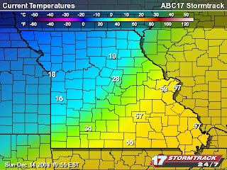
Check out the tight temperature gradient as the front is on our doorstep. At the time of this graphic, Fulton had around 45° where Columbia is at 28°.


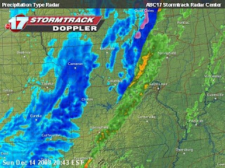
This image is the same graphic only showing the precip that was falling. Moderate rain began around 4:30 p.m. in the first band of post-frontal precip. After a short break in the rain, freezing rain fell, changing over to sleet for the remainder of the storm.

24 hr. storm totals:
Total Precip: 0.58"
Total Ice: 0.10"
New Snow: 0.40" (as IP)
Total Snow: 0.40"