Saturday, March 3, 2012
CoCoRaHS "Grand Slam"
If CoCoRaHS had a "Grand Slam", I imagine it would consist of observing "rain, hail, and snow" in one 24 hour period. That's just what we experienced at MO-CW-1 yesterday, March 2nd. Fueled by the same storm system that caused over 90 tornadoes East of Missouri later in the day, a cold front pushed strong and severe storms through our area around 6:00 am. We were suddenly woken up by a prolonged hail storm (lasted about 5 minutes) that completely covered the ground with nickel to quarter-sized hail. The hail remained on the ground for about 3 hours afterwards, with some help from rapidly dropping temperatures throughout the day. By day's end, the wrap-around moisture met us just as the air temperature was cool enough to support snow, and we ended up with a trace from the large flakes that fell mixed in with rain. I hadn't given it much thought before, but I can't remember a time that I saw "rain, hail, and snow" in one day.

Tuesday, February 14, 2012
3.2" February 13 Snow
Finally, a substantial amount has fallen in the Show-Me State. Most of Missouri has been blessed with a comfortable blanket of snow, and with temperatures only in the upper 20s/low 30s, it makes for great weather to get out and enjoy it.
The snow fell through most of the daylight hours yesterday, with periods of moderate to heavy snow in the afternoon. Below is a picture from the farm in Rolla caught around 4:00. Rolla ended up with around 4"

With temperatures climbing to the 40s and 50s later this week (the norm for winter '11-'12), our snow won't last. Flowers will start poking through next month!
The snow fell through most of the daylight hours yesterday, with periods of moderate to heavy snow in the afternoon. Below is a picture from the farm in Rolla caught around 4:00. Rolla ended up with around 4"

With temperatures climbing to the 40s and 50s later this week (the norm for winter '11-'12), our snow won't last. Flowers will start poking through next month!
Wednesday, January 18, 2012
Another 1.1" and Thoughts on Winter 11-12
Thursday, January 12 brought with it another 1.1" of snow. We were fortunate to not have school called off, although we were one of only three in Mid-MO that did not. Don't get me wrong, I love snow days, but with the warm winter we've been having, I haven't really felt the "need" to have a day off. The kids have been great, we've spent a lot of time outside, and we're kind of in this groove at school. Every January and February I teach Astronomy, but it is inevitably interrupted many times by snow days, wreaking havoc on any continuity required for deep understanding. So this year has been nice.
Again. I love snow days. Let's see if we get one this year.
My thoughts on this winter. I usually get quite upset if we go this long into the season without a nice snowstorm or two. But not this year. We have reached above 60 degrees and even 70 a number of times. I believe we have broken two high temperature records (at Columbia), and our rainfall has been somewhat average. I've really enjoyed it. I think the thing I have noticed and appreciate the most is the abundant sunshine. This pattern sure has many meteorologists puzzled, as Alaska and northern Canada have been in the deep freeze for most of the winter with temperatures steady in the -20 to -40s. Each week there is talk of this cold air spilling southward, and each week it stays where it is.
Groundhog day is only 2 weeks away. Lots can happen in two weeks in the midwest.
Again. I love snow days. Let's see if we get one this year.
My thoughts on this winter. I usually get quite upset if we go this long into the season without a nice snowstorm or two. But not this year. We have reached above 60 degrees and even 70 a number of times. I believe we have broken two high temperature records (at Columbia), and our rainfall has been somewhat average. I've really enjoyed it. I think the thing I have noticed and appreciate the most is the abundant sunshine. This pattern sure has many meteorologists puzzled, as Alaska and northern Canada have been in the deep freeze for most of the winter with temperatures steady in the -20 to -40s. Each week there is talk of this cold air spilling southward, and each week it stays where it is.
Groundhog day is only 2 weeks away. Lots can happen in two weeks in the midwest.
Thursday, December 8, 2011
First inch of '11-'12 Winter
Our first inch of snow came through Monday night, and took most everybody here by surprise. By 5:00 am, we had nearly half an inch on the ground and roads, which made it a slick drive to work. Snow fell steadily throughout the day, albeit in spurts between light snow and flurries. When the day was done, and after a bit of melting, we ended up with 1". Only missed that date by three days this year!
Calling for light snow tonight. I'm looking for a birthday snow!
Calling for light snow tonight. I'm looking for a birthday snow!
Tuesday, November 29, 2011
First possible accumulating snow
The snow contest board is up in the teacher workroom, and I feel good about my predictions this year. We try to predict the first accumulating snow (>T), first snow day, and total amount for the season. Here are this year's predictions:
First Accumulating: Dec. 3
First Snow Day: Dec. 9
Total Snow: 28.5"
It's funny to see how last year's 54" of snow affected everyone's predictions for this year. There are a lot of guesses in the 30s and 40s! That's an Oshkosh winter.
NBC Action News Weather Blog is showing a chance for snow this Saturday (the 3rd!), which could be the first for many in Missouri. I'm getting excited and am ready for the season to start.
First Accumulating: Dec. 3
First Snow Day: Dec. 9
Total Snow: 28.5"
It's funny to see how last year's 54" of snow affected everyone's predictions for this year. There are a lot of guesses in the 30s and 40s! That's an Oshkosh winter.
NBC Action News Weather Blog is showing a chance for snow this Saturday (the 3rd!), which could be the first for many in Missouri. I'm getting excited and am ready for the season to start.
Tuesday, March 15, 2011
What????
Surprise!! March 14 was supposed to be the beginning of our spring break, but our blizzard break from Jan. 31 - Feb 4 wiped all those day away. No complaints here, though. Much to our amazement, and the meteorological network's surprise, we were graced with another nice snowstorm! Forecasted to bring our area <1", we ended up with a total of 9.1" at this station. This brings our seasonal total to 51.2".
The snow fell as very large conglomerate flakes during much of the day. It was amazing. A co-worker said it reminded her of spring in Colorado.

The snow fell as very large conglomerate flakes during much of the day. It was amazing. A co-worker said it reminded her of spring in Colorado.

Wednesday, February 23, 2011
World Sunlight Map
In my research I often find some pretty interesting resources. I thought I'd share with anyone here who might find this interesting as well.
http://www.die.net/earth/
http://www.die.net/earth/
Monday, February 14, 2011
Exploding Snow
Found this video on another blog. I've seen some big ice chunks come off 18-wheelers, but never anything this bad.
Saturday, February 5, 2011
February 1, 2011 Blizzard Review
Posting some links to NWS reviews for the blizzard:
St. Louis Office
Chicago Office
Central Illinois Office (links to other regions can be found here)
Many thanks to the National Weather Service for the work they did predicting and analyzing this historic storm.
St. Louis Office
Chicago Office
Central Illinois Office (links to other regions can be found here)
Many thanks to the National Weather Service for the work they did predicting and analyzing this historic storm.
Thursday, February 3, 2011
Tuesday, February 1, 2011
Blizzard '11 - February 1
7:30 p.m.
The wrap around moisture from the storm has come and gone in a hurry. We experienced a short time with moderate snowfall and light winds as the low pressure system traveled nearby. Now that it is on its way to the NE, we are officially on the back side of the storm and into the 3rd phase, windy and bitterly cold.
My final observation was at 7:05, bringing the storm total to 16.0". This is of course assuming we don't experience any more wrap around moisture.
Here are my final snowfall observations (pending any additional snow tonight)

Snowfall rates started off light but quickly became incredibly intense. By the 10:00 hour, we were pushing 2.0"/hr and many places were reporting the same. I read a few reports in areas north and west of here experiencing thundersnow, but didn't hear any today.
Storm average snowfall rate from the period of 5:30 am to 7:30 pm: 1.14"/hr
Photos and Videos
Video #2 - From earlier in the day
Video #3 - Nearing the end of the storm; shows some of the amazing drifts
More photos from the storm can be found here.
______________________________
2:30 p.m.
I could only imagine what a blizzard looks like, and what I'm seeing now is the image I've had. But I never realized what a blizzard feels like. It kinda puts your senses on edge. Our winds are now sustained at 23 mph and gusting 35-40. I feel like something could give at any time. And that makes me nervous.
12:05 p.m. | 7.5"
1:05 p.m. | 8.5"
2:05 p.m. | 10.0"
______________________________
11:30 a.m.
At midday, snow has been falling for 6 hours. Moderate snow has been the norm with periods of heavy snow. At the most, we have had 2"/hr rates. Snow is getting difficult to measure, so I've had to start taking multiple measurements. Here are the 2 observations I've taken since last observation:
10:05 a.m. | 4.0"
11:05 a.m. | 5.7"
Our power went out for a minute or two a little while ago. It made the sober reality set in for my wife and I. There are reports of power outages since 10:30 just south of Mexico (25 min north of here).
______________________________
9:05 a.m.
Snow started falling this morning around 5:30, and increased in intensity very rapidly. Moderate and heavy at times, the snow quickly covered the ground. Winds have been light at times and brisk at others, nothing extreme yet.
Total Snow: 2.0"

This video shows our current snowfall rates, as of 9:05 a.m.
The wrap around moisture from the storm has come and gone in a hurry. We experienced a short time with moderate snowfall and light winds as the low pressure system traveled nearby. Now that it is on its way to the NE, we are officially on the back side of the storm and into the 3rd phase, windy and bitterly cold.
My final observation was at 7:05, bringing the storm total to 16.0". This is of course assuming we don't experience any more wrap around moisture.
Here are my final snowfall observations (pending any additional snow tonight)

Snowfall rates started off light but quickly became incredibly intense. By the 10:00 hour, we were pushing 2.0"/hr and many places were reporting the same. I read a few reports in areas north and west of here experiencing thundersnow, but didn't hear any today.
Storm average snowfall rate from the period of 5:30 am to 7:30 pm: 1.14"/hr
Photos and Videos
Video #2 - From earlier in the day
Video #3 - Nearing the end of the storm; shows some of the amazing drifts
More photos from the storm can be found here.
______________________________
2:30 p.m.
I could only imagine what a blizzard looks like, and what I'm seeing now is the image I've had. But I never realized what a blizzard feels like. It kinda puts your senses on edge. Our winds are now sustained at 23 mph and gusting 35-40. I feel like something could give at any time. And that makes me nervous.
12:05 p.m. | 7.5"
1:05 p.m. | 8.5"
2:05 p.m. | 10.0"
______________________________
11:30 a.m.
At midday, snow has been falling for 6 hours. Moderate snow has been the norm with periods of heavy snow. At the most, we have had 2"/hr rates. Snow is getting difficult to measure, so I've had to start taking multiple measurements. Here are the 2 observations I've taken since last observation:
10:05 a.m. | 4.0"
11:05 a.m. | 5.7"
Our power went out for a minute or two a little while ago. It made the sober reality set in for my wife and I. There are reports of power outages since 10:30 just south of Mexico (25 min north of here).
______________________________
9:05 a.m.
Snow started falling this morning around 5:30, and increased in intensity very rapidly. Moderate and heavy at times, the snow quickly covered the ground. Winds have been light at times and brisk at others, nothing extreme yet.
Total Snow: 2.0"

This video shows our current snowfall rates, as of 9:05 a.m.
Monday, January 31, 2011
Blizzard '11 - January 31
A historic event is expected to unfold in mid-Missouri, and in fact in most of Missouri tomorrow and Wednesday. Having grown up in Missouri, I have seen snow storms come and go. Most of the 'big' storms have been such that provided a nice blanket of 6-10" (as we just experienced on the 20-21st), and I can count on one hand the times we have had extreme snowfalls of 12-15". Nothing comes close to what has been churning for the past few days, and what may possibly come through in the next 12 hours.
The Setup
A split flow in the jet stream has merged dropping down a large polar air mass that is expected to bring sub-zero temperatures by Wednesday night. At the same time, a huge storm will be ejected out of Texas bringing an enormous amount of moisture tapped from the gulf. Below is a graphic showing the projected path of the surface low that will cause this storm.

Here is the 2-day Quantitative Precipitation Forecast valid Monday night:

These amounts are extreme, even during spring torrents that visit the area. But to have a snowstorm bring such rain is unprecedented during this generation.
On the right side of my blog, I show the NWS STL graphical snow forecast. This changes with each cycle of the model runs, and this image was captured at 6:00 am Tuesday morning. Amazing totals.

Finally, a first has happened in the history of the NWS STL. Never before have they issued a Blizzard Warning for their CFA. As you can see below, much of Missouri is under a blizzard warning from 6 am Tuesday till noon Wednesday. Blizzard conditions include heavy snow, 35+ mph sustained winds, and 1/4 mile visibility for at least 3 hours.

Of course, this storm is not affecting only our area. Many people will be affected by this dangerous system across the country. A crippling ice storm is expected for southern Illinois into Indiana, and the heavy snow will continue northeastward into the already battered New England states. The warning map below was captured early this afternoon.

The Setup
A split flow in the jet stream has merged dropping down a large polar air mass that is expected to bring sub-zero temperatures by Wednesday night. At the same time, a huge storm will be ejected out of Texas bringing an enormous amount of moisture tapped from the gulf. Below is a graphic showing the projected path of the surface low that will cause this storm.

Here is the 2-day Quantitative Precipitation Forecast valid Monday night:

These amounts are extreme, even during spring torrents that visit the area. But to have a snowstorm bring such rain is unprecedented during this generation.
On the right side of my blog, I show the NWS STL graphical snow forecast. This changes with each cycle of the model runs, and this image was captured at 6:00 am Tuesday morning. Amazing totals.

Finally, a first has happened in the history of the NWS STL. Never before have they issued a Blizzard Warning for their CFA. As you can see below, much of Missouri is under a blizzard warning from 6 am Tuesday till noon Wednesday. Blizzard conditions include heavy snow, 35+ mph sustained winds, and 1/4 mile visibility for at least 3 hours.

Of course, this storm is not affecting only our area. Many people will be affected by this dangerous system across the country. A crippling ice storm is expected for southern Illinois into Indiana, and the heavy snow will continue northeastward into the already battered New England states. The warning map below was captured early this afternoon.

Friday, January 28, 2011

Wednesday, January 19, 2011
Snow January 19-20
::Update::
I've added a couple of videos from the storm. The first one is at my first observation at 5:00 p.m.
This next video was at 11:00 p.m., my last observation before morning. 5.4" on the ground at the time.
_________________________________
Jan 20
9:15 a.m.
Total Snow: 8.5"
Light snow is steady but tapering off. Wind N 12 mph


Find more pictures HERE
_________________________________
Jan 20
6:00 a.m.
Total Snow: 8.2"
What a cool sight this is! We haven't had this much snow fall since the big storm on Nov. 30-Dec. 1 2006. It's been a long time coming. Presently, light snow is falling with a light north wind.

_________________________________
Jan 19
11:00 p.m.
Total Snow: 5.4"
Moderate snowfall still occurring at this time. Wind N 13mph

_________________________________
Jan 19
9:30 p.m.
Total Snow: 3.8"
Snow rate has intensified, as we have picked up an additional 1.9" over the past hour and 45 minutes.
_________________________________
Jan. 19
7:45 p.m.
Total Snow: 1.9"
Wind has picked up a bit close to 10 mph out of NE. Light to moderate snow.

_________________________________
Jan. 19
6:40 p.m.
Total Snow: 1.2"
Light to moderate snow falling, little to no wind

_________________________________
Jan. 19
5:00 p.m.
Total Snow: 0.25"
Snow began lightly around 4:15, and is quickly intensifying. It didn't take long for the roads to slicken up.


I've added a couple of videos from the storm. The first one is at my first observation at 5:00 p.m.
This next video was at 11:00 p.m., my last observation before morning. 5.4" on the ground at the time.
_________________________________
Jan 20
9:15 a.m.
Total Snow: 8.5"
Light snow is steady but tapering off. Wind N 12 mph


Find more pictures HERE
_________________________________
Jan 20
6:00 a.m.
Total Snow: 8.2"
What a cool sight this is! We haven't had this much snow fall since the big storm on Nov. 30-Dec. 1 2006. It's been a long time coming. Presently, light snow is falling with a light north wind.

Jan 19
11:00 p.m.
Total Snow: 5.4"
Moderate snowfall still occurring at this time. Wind N 13mph

_________________________________
Jan 19
9:30 p.m.
Total Snow: 3.8"
Snow rate has intensified, as we have picked up an additional 1.9" over the past hour and 45 minutes.
_________________________________
Jan. 19
7:45 p.m.
Total Snow: 1.9"
Wind has picked up a bit close to 10 mph out of NE. Light to moderate snow.

_________________________________
Jan. 19
6:40 p.m.
Total Snow: 1.2"
Light to moderate snow falling, little to no wind

_________________________________
Jan. 19
5:00 p.m.
Total Snow: 0.25"
Snow began lightly around 4:15, and is quickly intensifying. It didn't take long for the roads to slicken up.


Monday, January 10, 2011
January 10-11 Snow
Snow fell again in mid-Missouri, and it's a beautiful sight. Around 11:00 am, light snow began to fall, and throughout the day, we experienced steady moderate snowfall, tapering to light snow by evening and finally ending around 3:00 a.m. This morning, the 11th, we have frigid air spilling in. Currently it is 12° with a wind chill reading around 5.


______________________________________________
Jan. 11, 4:30 a.m. observation:
Snow has stopped around 3:00 a.m.. The wind has started to pick up a bit as this storm makes its way by us.
Total Snow: 4.6"
______________________________________________
Jan. 10, 9:45 p.m. observation:
Still snowing at this time. The intensity has definitely tapered off, and the east wind has all but quit. Currently, light snow is falling with some nice conglomerate flakes mixed in.
Total Snow: 2.9"
SWE: 0.25" (11.6 : 1)

______________________________________________
Jan. 10, 6:30 p.m. observation:
2.4" and still snowing


______________________________________________
Jan. 11, 4:30 a.m. observation:
Snow has stopped around 3:00 a.m.. The wind has started to pick up a bit as this storm makes its way by us.
Total Snow: 4.6"
______________________________________________
Jan. 10, 9:45 p.m. observation:
Still snowing at this time. The intensity has definitely tapered off, and the east wind has all but quit. Currently, light snow is falling with some nice conglomerate flakes mixed in.
Total Snow: 2.9"
SWE: 0.25" (11.6 : 1)

______________________________________________
Jan. 10, 6:30 p.m. observation:
2.4" and still snowing

Saturday, December 25, 2010
Christmas Eve Snow
It's not often we get snow on Christmas, and it's even less often that we get it two years in a row. Last Christmas, the middle of the country was graced with a powerful storm that spun into the area, sat on Iowa for a while, and went on its way, giving millions of people a white Christmas. Although we didn't measure much snow from that system, it was impressive and memorable. Here's a link from last year's post.
This year's storm was a different beast. It was faster, and gave us a beautiful wet snow all day Christmas Eve. We were in Rolla visiting my family, and watching the snow falling slowly through the bare trees was awesome. I took the liberty of bringing one of my extra rain gauges on our travel to measure the water content of the snow. It was a wet 9.3 : 1 ratio. Contrast that to the nearly 20 : 1 snow we had on the 11th. Geez, if this snow had that ratio, our snow total would have more than doubled. That made me wonder on our trip home...what is/are the factors that affect this ratio? I assume primarilly temperature. I also assume that one could accurately predict the type of snow based on this factor, which could end up saving cities money on salt/cinder they throw on the roads...but I digress.
In Rolla, I measured 2.8", which melted down to 0.30". In Fulton, we ended up with 3.5" melting down to 0.37". The roads are great...dry in fact, which I presume is a result of the wet snow. That's what led me to my inquiries above during our drive home today.
Merry Christmas!
This year's storm was a different beast. It was faster, and gave us a beautiful wet snow all day Christmas Eve. We were in Rolla visiting my family, and watching the snow falling slowly through the bare trees was awesome. I took the liberty of bringing one of my extra rain gauges on our travel to measure the water content of the snow. It was a wet 9.3 : 1 ratio. Contrast that to the nearly 20 : 1 snow we had on the 11th. Geez, if this snow had that ratio, our snow total would have more than doubled. That made me wonder on our trip home...what is/are the factors that affect this ratio? I assume primarilly temperature. I also assume that one could accurately predict the type of snow based on this factor, which could end up saving cities money on salt/cinder they throw on the roads...but I digress.
In Rolla, I measured 2.8", which melted down to 0.30". In Fulton, we ended up with 3.5" melting down to 0.37". The roads are great...dry in fact, which I presume is a result of the wet snow. That's what led me to my inquiries above during our drive home today.
Merry Christmas!
Thursday, December 16, 2010
Cold Start to December / Dec 16 Ice
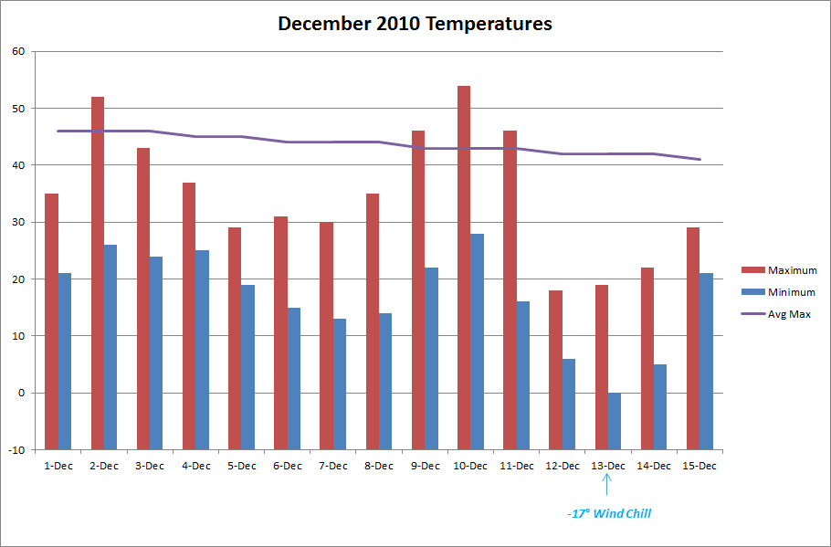
We have experienced a colder than normal start to the month with a mean temperature of 26.0°, a -8.2° departure for the period of Dec. 1-15. As seen from the chart below temperatures have been below average, but of note are two periods of cold (4-8) and (12-15). Both brought breezy canadian air with it, and the latter gave us our 2" mini-blizzard on the 11th and 12th.

Ice Dec. 15-16
An upper-level disturbance is bringing snow to the upper plains and through to the east coast. As it developed, it brought light freezing drizzle/rain to our area. Barely enough to measure in the rain gauge, but it was enough to create a thin glaze on roads and elevated surfaces (enough to call off schools even). Below is this morning's radar showing the long band of snow affecting the nation.

Ice Dec. 15-16
An upper-level disturbance is bringing snow to the upper plains and through to the east coast. As it developed, it brought light freezing drizzle/rain to our area. Barely enough to measure in the rain gauge, but it was enough to create a thin glaze on roads and elevated surfaces (enough to call off schools even). Below is this morning's radar showing the long band of snow affecting the nation.

Sunday, December 12, 2010
Dec. 11-12 Winter Storm

(Source: NWS STL)
Update 8:00 a.m.
The snow ended early this morning and the wind didn't let up a bit all night. With gusts sustaining in the upper 30 mph range, it made for some difficult snow measurements this morning. I made multiple measurements around the yard, and came up with a 2.0" total. This storm reminds me of the January 6-7, 2010 storm. Strong NW winds made similar drifting patterns, although more exaggerated due to double the amount of snow then. Pictures from that storm can be found here. Compare those with this year's storm.
Here are a couple of pictures from the storm:


Update 12:00 a.m.
Snow is currently falling with vigor in Missouri again. After much anticipation, we will reach our first inch tonight. We reached our maximum temperature of 46° around 10:00 am, and by 10:00 pm we were at 17°. Morning rain changed to a mist, and then quit for a while. Around 2:00 we started seeing flurries flying around, which intensified bit by bit through the evening hours. Tonight, at 12:00 am snow is falling at a moderate rate and wind gusts are reaching 40 mph. The current temp is 16°.
I tried to make a measurement, and my best estimation is a current depth of 0.5". Below is a video I shot and the coinciding radar image at 11:45 pm.

Tuesday, December 7, 2010
November Weather Summary
The dry weather continues this month. After an extremely arid 0.54" total for October, we ended up with a slightly better 1.74" for the month of November. The dry months stick out to us lately, since we haven't really experienced any prolonged stretches of dry weather patterns in the past three years. I did a quick data check. Over the past 36 months, 27 of them have exceeded the normal precip amounts, and only 9 have had deficits. The months with deficits, ranging from 1/2008 - 11/2010 are:
Aug 08
Nov 08
Jan 09
Nov 09
Mar 10
May 10
Jun 10
Oct 10
Nov 10
It's interesting to note that the past three Novembers have run on the low side of precipitation.
Temperature

Mean Temp: 45.9°
Deviation: 2.7°
Maximum: 75° on Nov. 10
Minimum: 18° on Nov. 26
Precipitation

Average November: 3.85"
Actual November: 1.74" (-2.11")
Days with measurable precip: 7
Snow
We did see our first flakes of the year on the 30th. Some midday flurries and light snow just blew around, but made for a welcomed sight for me. It's hard for me to imagine, but our average snowfall for November is 1.6"
Other Weather Info:
Days with thunder: 2
Days with fog: 1
Days with wind gust (>= 20 mph): 20
Aug 08
Nov 08
Jan 09
Nov 09
Mar 10
May 10
Jun 10
Oct 10
Nov 10
It's interesting to note that the past three Novembers have run on the low side of precipitation.
Temperature

Mean Temp: 45.9°
Deviation: 2.7°
Maximum: 75° on Nov. 10
Minimum: 18° on Nov. 26
Precipitation

Average November: 3.85"
Actual November: 1.74" (-2.11")
Days with measurable precip: 7
Snow
We did see our first flakes of the year on the 30th. Some midday flurries and light snow just blew around, but made for a welcomed sight for me. It's hard for me to imagine, but our average snowfall for November is 1.6"
Other Weather Info:
Days with thunder: 2
Days with fog: 1
Days with wind gust (>= 20 mph): 20
Friday, December 3, 2010
Supercell Pictures
http://www.dailymail.co.uk/sciencetech/article-1334672/Jaw-dropping-image-enormous-supercell-cloud-Glasgow-Montana.html
Follow this link for some awesome July storm pictures from storm photographer Sean Heavey
Follow this link for some awesome July storm pictures from storm photographer Sean Heavey
Subscribe to:
Posts (Atom)