 Thunderstorms erupted ahead of a cold front this evening bringing some intense rain to parts of Mid-Missouri. We had partly sunny skies all day, with clouds building more and more as the day progressed. By 5:30 p.m., I could start to hear thunder in the area. We experienced a storm approaching from the SW at 6:00 p.m. As it was approaching, I was able to snap a shot of the accompanying shelf cloud as seen here.
This storm brought a little lightning, and brief heavy rain. We ended up receiving 0.29" in 20 minutes. Columbia reported heavy rain to the tune of one inch in just 30 minutes. They are 20 miles from us.
The storm that passed quickly cooled us off. Tomorrow's high temps shouldn't reach 70. Gotta love Missouri.
More storms and showers expected tonight. There is the threat for these storms to set up in the same area all night bringing with it some flooding. Some areas may have 2-3" when the low pressure system makes its farewell late tomorrow.
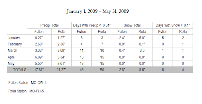
MO-CW-1 (Fulton) : MO-PH-5 (Rolla) -- A Comparison
My Dad joined CoCoRaHS in March, 2008. Since then I've had the pleasure of comparing precipitation data between us. Tonight, I filed through both of our reports since January 1 of this year, using categories submitted in my yearly Water Year Report.
Station Locations:

Stations are roughly 65 miles apart

On first glance, it's easy to note that MO-PH-5 has caught around 3.5" more than we have. You can also conclude that they experienced measurable precipitation 1 out of every 3 days. While the snow data does not summarize total snowfall for the season, you can see that MO-PH-5 received considerably more snow than we did...even though we had more "snow" events. I credit that to more available moisture where they are.
3 comments:
Great comparison!!!! I'm glad I let you do that, rather than me! :) If you get really bored, you can do that including my station (once I finally have a complete month of reporting!)
We received 1.58" of rain over the past 24 hours. Some street flooding as the rain came very heavy yesterday evening. By the time I got home, around 6:30, we already had .56".
Have a wonderful day!
The shelf cloud image is great. I recall seeing those while we lived in Texas - both west and southeast TX.
I like to your comparison data as well. It is always interesting to see differences in WX stations in the same region.
Bob
WxWatcher, we haven't had many awe inspiring clouds around here lately. On Friday, though, we did have some moderate sized cumulus views as the showers moved east late in the afternoon. So, I thank you for sharing you shelf cloud!
As Bob stated, it's very interesting to compare data from the same region. I appreciate your effort in the publishing of the comparison data. Keep up the great work!
Post a Comment