May has been tricky this year. We started out with clear blue skies, and for the most part above average temperatures. But the last eight days have been a much different story. While it hasn't come in abundance each day, it has rained on and off - sometimes very heavy, sometimes just a steady mist. But the fact remains that it has soaked us. The eight day total is 3.45", which is 69% of our May average.
Some Mid-May Stats:
(May 1 - 17)
Mean Temp: 59° (2.6°)
Precip Total: 3.69"
Days With Thunder: 7
Days With Fog: 3
Days With Wind Gust (>= 20 mph): 5
As of today, I've mowed the lawn 4 times. The chives are looking beautiful - I'll have pictures of them on my monthly summary. Not a cloud in the sky today...I'm looking for some time to dry out!
Tuesday, May 18, 2010
Saturday, May 1, 2010
April Weather Summary
-----** Additional Yearly Data Updated on 5/5/10 **-----
April in Missouri can be a wild time. The transition between Winter and Summer can cause some intense battles between air masses, and the midwest is fortunate (or, depending on your view--unfortunate) to receive the brunt of these clashes. While we did have a couple of very weak tornadoes in and around the area, there was no real severe weather to write home about. April can be split up into three segments this year: Wind, warmth, and water.
Wind
50% of the month could be classified as "breezy" (gusts =< 20 mph), as we experienced 15 days meeting that criteria. The first 8 days of the month were incredibly breezy, as they finished off a 10-day period of windy weather. The top wind gust of 40 mph occurred on April 23rd as a strong bow echo passed through. You can view the data HERE.
Warmth
Take a look at the temperature graph. You'll see that of the first 15 days, we experienced a high temperature below average only once. The high temperature during those 15 days averaged at 77.5°, where the normal average high for that period was 63.6°, a 13.9° difference. OSNW3 experienced the same warmth in Wisconsin. For his perspective of April from the upper-midwest, click HERE.
Water
The last 10 days of the month experienced an active weather pattern that brought most of our monthly precip total. Collectively, we recorded 2 days with precip above 1", with our one-day max occurring on the 24th of 3.02". We exceeded our monthly average by 2.58".
Temperature
Mean Temp: 60.9°
Deviation: +6.5°
Maximum: 87° on Apr. 1
Minimum: 36° on Apr. 9
Precipitation
Average April: 3.96"
Actual April: 6.54" (+2.58")
Average April Snow: 0.6"
Actual April Snow: 0.0" (0.6)
Days With Measurable Precip: 11
As the year goes on, count on seeing more bars on the heavy side of the graph.
To compare this April with the past two years:
Other Weather Info
Days With Thunder: 7
Days With Fog: 4
Days With Wind Gust (>= 20 mph): 15
Yearly Weather Info
With the year a quarter of the way done, here's some miscelaneous data:
Max Temp: 87° on Apr. 1
Min Temp: -5° on Jan. 9
Greatest 1-day Precip: 3.02" on Apr. 24
Greatest 1-day Snow: 5.4" on Jan. 6
Days With Thunder: 11
Days With Fog: 21
Days With Wind Gust (>= 20 mph): 28
# of Mows: 2
Monday, April 5, 2010
March Weather Summary
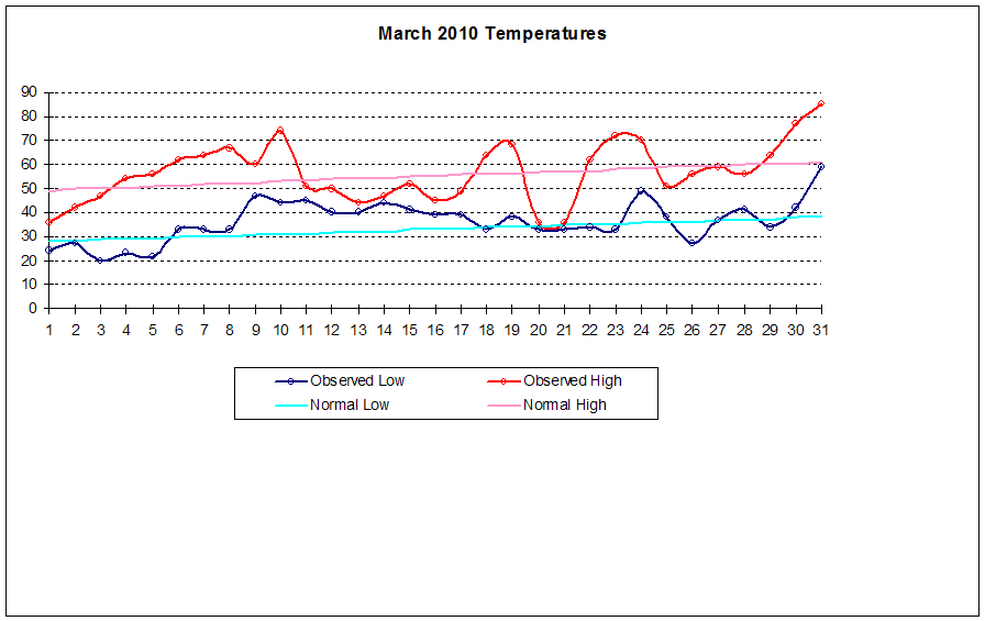
Another textbook month for Mid-Missouri. March offered a nice respite from the usual suspects of winter by bringing more warmth, humidity, thunder, and more color to the area. Old man winter seemed to get one more punch in on the 20th with a day filled with snow to our west and sleet in the Fulton/Jeff City area. Other than that, it was a very nice spring-filled month. Especially the last week. OSNW3, it definitely went out like a lamb here, too.
March Daily Observations
Temperature
In typical March fashion, temperatures fluxuated (though not wildly) throughout the month. The spread occurred from the beginning of the month to the end.
Mean Temp: 46.5°
Deviation: 2.4°
Maximum: 85° on Mar. 31
Minimum: 20 on Mar. 3
Precipitation
Average March: 3.14"
Actual March: 2.74" (-0.40")
Average March Snow: 3.4"
Actual March Snow: 0.1" (-3.3")
Days with Measurable Precip: 10
Days with Measurable Snow: 1
Days with Snow Cover (>0.1"): 1
Days with Precip:
Average Monthly Total: 3.14"
As you can see, we haven't hit our 3.4" of snow mark, nor gotten even close to it for three years now. Spring has been coming early for us.
Other Weather Info
Days With Thunder: 2
Days With Fog: 4
Days with wind gust (>= 20 mph): 3
March Daily Observations
Temperature
In typical March fashion, temperatures fluxuated (though not wildly) throughout the month. The spread occurred from the beginning of the month to the end.
Mean Temp: 46.5°
Deviation: 2.4°
Maximum: 85° on Mar. 31
Minimum: 20 on Mar. 3
Precipitation
Average March: 3.14"
Actual March: 2.74" (-0.40")
Average March Snow: 3.4"
Actual March Snow: 0.1" (-3.3")
Days with Measurable Precip: 10
Days with Measurable Snow: 1
Days with Snow Cover (>0.1"): 1
Days with Precip:
Average Monthly Total: 3.14"
As you can see, we haven't hit our 3.4" of snow mark, nor gotten even close to it for three years now. Spring has been coming early for us.
Other Weather Info
Days With Thunder: 2
Days With Fog: 4
Days with wind gust (>= 20 mph): 3
Saturday, March 20, 2010
Signs of Spring
Thunderstorms, Tornadoes, Tasty Herbs, and Trout. All have been signs that Spring is finally here in Missouri. Even the mix of rain, sleet and snow as of this posting isn't dampening my spirits. I feel renewed and refreshed by the warmer weather and SUN that has been greeting us--although fleetingly--lately. What follows are three glimpses of spring that makes this weather lover and outdoor enthusiast smile.
March 10 -- Thunderstorms...Tornado
March 10 gave us three "firsts" this year. The first day above 70°, first day with thunder, and first tornado warning (and confirmed EF0). The temperature climbed up to 74° under a sunny sky, the climax of a week's worth of rising temperatures. In the spring, though this usually brings the same anticipation as climbing up the hill on a rollercoaster. You know that after you peak, you're in for a rough ride. And, to a point, we did on that Wednesday.
I hurried to get the steaks grilled that afternoon (oh, another "first" for the year) as I could see the dark clouds coming in, and even reports of Severe Weather in the area. We had a little storm pass around 4:30 pm. By bedtime, I had no reason to believe there would be any more severe weather. I was awaken at 10:30 with the town's tornado siren, and thought "surely that couldn't be!". Sure enough, there was a doppler indicated tornado south of the area, moving slightly to our East. After some tense moments, the storm passed with no incident. Fulton spotters reported 1" hail, but I didn't have anything at my location. Appropriately, this was Missouri's Severe Weather Awareness Week.
Tasty Herbs
Picture taken on March 12. The plants in the middle are Columbines, and Chives are popping out of the ground. I was able to use some on my potatoes and trout dinner a couple of days ago. Tasted like summer!
Trout Fishing!
Trout season opens March 1st in Missouri, and I made my first outing last Wednesday. It was a cloudy morning, but the sun peeked out after noon. It was a magnificently fulfilling day. I can't imagine a better way to view God's beauty than the Missouri outdoors.
1st Day of Spring
Today is the first day of spring (as of 12:32 pm), and we have 2" of snow predicted for the area. 62° by Tuesday.
March 10 -- Thunderstorms...Tornado
March 10 gave us three "firsts" this year. The first day above 70°, first day with thunder, and first tornado warning (and confirmed EF0). The temperature climbed up to 74° under a sunny sky, the climax of a week's worth of rising temperatures. In the spring, though this usually brings the same anticipation as climbing up the hill on a rollercoaster. You know that after you peak, you're in for a rough ride. And, to a point, we did on that Wednesday.
I hurried to get the steaks grilled that afternoon (oh, another "first" for the year) as I could see the dark clouds coming in, and even reports of Severe Weather in the area. We had a little storm pass around 4:30 pm. By bedtime, I had no reason to believe there would be any more severe weather. I was awaken at 10:30 with the town's tornado siren, and thought "surely that couldn't be!". Sure enough, there was a doppler indicated tornado south of the area, moving slightly to our East. After some tense moments, the storm passed with no incident. Fulton spotters reported 1" hail, but I didn't have anything at my location. Appropriately, this was Missouri's Severe Weather Awareness Week.
Tasty Herbs
Picture taken on March 12. The plants in the middle are Columbines, and Chives are popping out of the ground. I was able to use some on my potatoes and trout dinner a couple of days ago. Tasted like summer!
Trout Fishing!
Trout season opens March 1st in Missouri, and I made my first outing last Wednesday. It was a cloudy morning, but the sun peeked out after noon. It was a magnificently fulfilling day. I can't imagine a better way to view God's beauty than the Missouri outdoors.
1st Day of Spring
Today is the first day of spring (as of 12:32 pm), and we have 2" of snow predicted for the area. 62° by Tuesday.
Saturday, March 6, 2010
"What Will Fall and Winter Bring" revisited
Back in August, I posted a comment based on a little research I did into the effects (if any) of an extremely cool summer (find the post HERE). July 2009 gave us some very below-average temps, and although there were no complaints to be heard, I was curious how the fall and winter would play out. Now that the books are filled in, I'd like to revisit that post and see how our data compared with the previous 9 coldest July's.
Fall temperatures didn't impress me either way. If we deviated, it wasn't by too much. The maximum deviation were by 3.1° or 3.2° during these years. This year's fall was no different, only slightly cooler than normal.
Winter temperatures offer the same in the way of deviations. The average of all ten of these years came out to 31.9°, where the normal was 32.0°. This winter's deviation was -3.7°. Below average has been very common for the past 6 months. I wonder if El Nino has something to do with that.
Precipitation is the hot topic for fall and winter. For fall precip, this year and 1905 were quite the outliers with a surplus of +10.05" and +9.61", respectively. Abundant gulf moisture in October was the ticket this year, with 12.49" falling in just one month!
Winter precipitation is a much more telling story. Look at all the black in that column. Surplus precipitation seems very likely, with only one year shorting us a mere -0.19". We followed suit this year with a surplus of +3.08".
Snowfall amounts during these ten sample years are below average. The mean snowfall amounts for these years is 2.4" below average. This year, even with an abundance of days with measurable snow, we still fell short (barring any late-season snowstorms of course). We ended up behind by 1.8" with a total of 18.6".
So how does our friend El Nino play into this? Not sure...but this is the only year (2009) on the data table above that occurs during an official El Nino event. Two years on the table (1950, and 1971) occur one year before a major El Nino event.
Winter temperatures offer the same in the way of deviations. The average of all ten of these years came out to 31.9°, where the normal was 32.0°. This winter's deviation was -3.7°. Below average has been very common for the past 6 months. I wonder if El Nino has something to do with that.
Precipitation is the hot topic for fall and winter. For fall precip, this year and 1905 were quite the outliers with a surplus of +10.05" and +9.61", respectively. Abundant gulf moisture in October was the ticket this year, with 12.49" falling in just one month!
Winter precipitation is a much more telling story. Look at all the black in that column. Surplus precipitation seems very likely, with only one year shorting us a mere -0.19". We followed suit this year with a surplus of +3.08".
Snowfall amounts during these ten sample years are below average. The mean snowfall amounts for these years is 2.4" below average. This year, even with an abundance of days with measurable snow, we still fell short (barring any late-season snowstorms of course). We ended up behind by 1.8" with a total of 18.6".
So how does our friend El Nino play into this? Not sure...but this is the only year (2009) on the data table above that occurs during an official El Nino event. Two years on the table (1950, and 1971) occur one year before a major El Nino event.
Monday, March 1, 2010
February Weather Summary
Cold and snowy, just as I like winters in Missouri. I've said before that I don't mind the cold weather, as long as we get to enjoy some snow along with it. Last year's winter seemed to drag on and on with our measley snow amounts (February 2009 recorded 0.0" of the stuff). But this year was a nice turn around. We had 7 days with measurable snow, and 11 days that snow was falling from the sky. Although our winter-season snowfall amounts aren't impressive (only average at best), it has been described by many around here as a very "snowy" winter. That is due to the fact that we've had many days with minimal accumulations, and below-average temperatures made sure that it stuck around.
Speaking of which, so far this winter we have recorded snow on the ground 37 days. Now, I'm not sure what is normal, but I am certain that this amount is higher than average. Again, lower temperatures has been the cause of this. Normally, a snow will last anywhere from a couple of hours to a couple of days. This month alone, we saw a 15-day stretch with a snow pack.
February Daily Observations
Temperatures
Mean Temp: 28.4°
Deviation: (5.3°)
Maximum: 48° on Feb. 28
Minimum: 2° on Feb. 9
Heating Degree Days: 1024 | 791 Last Year
Cooling Degree Days: 0
Bob and OSNW3 have reported above average temperatures this February. I don't know what they're doing right, but we can't hardly get above average! We only had 4 days where the high temperature acheived a higher mark than average. The official Columbia NWS station only recorded one! It has been a chilly month in Missouri. A local fruit tree farmer told me that she will probably not have any peaches or apricots this year because of it.
Other Weather Info
Days with thunder: 0
Days with fog: 3
Days with wind gust (>= 20 mph): 3
Speaking of which, so far this winter we have recorded snow on the ground 37 days. Now, I'm not sure what is normal, but I am certain that this amount is higher than average. Again, lower temperatures has been the cause of this. Normally, a snow will last anywhere from a couple of hours to a couple of days. This month alone, we saw a 15-day stretch with a snow pack.
February Daily Observations
Temperatures
Mean Temp: 28.4°
Deviation: (5.3°)
Maximum: 48° on Feb. 28
Minimum: 2° on Feb. 9
Heating Degree Days: 1024 | 791 Last Year
Cooling Degree Days: 0
Bob and OSNW3 have reported above average temperatures this February. I don't know what they're doing right, but we can't hardly get above average! We only had 4 days where the high temperature acheived a higher mark than average. The official Columbia NWS station only recorded one! It has been a chilly month in Missouri. A local fruit tree farmer told me that she will probably not have any peaches or apricots this year because of it.
Precipitation
Average February: 2.17"
Actual February: 2.59" (+0.42")
Average February Snow: 5.8"
Actual February Snow: 7.0" (+1.2")
Days with Measurable Precip: 10
Days with Measurable Snow: 7
Days with Snow Cover (>.01): 15
Days with Precip:
Precip Average: 2.17"
We have hit our average precip for the last three years.
Other Weather Info
Days with thunder: 0
Days with fog: 3
Days with wind gust (>= 20 mph): 3
Monday, February 8, 2010
February 8-9 Snow
Yesterday was a beautiful, sunny day. The roads had finally dried, yet snow was still prevalent on the yards and fields (except for a neighbor's yard, where nearly all their snow was used up in constructing a 10' snow monster!) Clouds began to drift in from the west by evening, and overnight, light snow developed in our area and across Missouri.
The air temperature is 6° colder than during Friday's snow. This has completely changed the structure of the snow that's falling, along with the snow-water ratio (which was 6.3 : 1) . Today's snow is a very light, disc-like flake that acts like a million reflectors on the ground.

The air temperature is 6° colder than during Friday's snow. This has completely changed the structure of the snow that's falling, along with the snow-water ratio (which was 6.3 : 1) . Today's snow is a very light, disc-like flake that acts like a million reflectors on the ground.
:: Feb. 8, 6:00 a.m. ::
New snow: 0.7"
SWE: 0.07"
Water Ratio: 10 : 1
Storm Total: 0.7"
Total Snow: 2.5"
(new snow)
(total snow)
What a beautiful day it has been! After this morning's observation, we got the call from school that we'd be staying home. I headed into town to get a cup of coffee and enter the first part of today's entry. On my way back home, I was treated with some sun dogs. I typically see these on the other part of the sky, at evening (although, I usually drive to work before the sun comes up, too). I just happened to have my camera with me:

The sun came out shortly after this picture was taken (roughly 7:30 a.m.), and we had partly sunny skies for a moment or two. The snow didn't pick up again until around noon (giving us the chance to head to Columbia and hit Bass Pro *score!*). Our temperatures hovered just above freezing for the majority of the day, so any snow that fell melted as soon as it hit the ground. I feel that this greatly impacted our storm total amount. It has been snowing at a steady rate since noon, and it is still snowing.
However...the accumulation didn't begin until late evening, when the temperature dropped below freezing once again. Hence the long break between observations.
:: Feb 8, 9:30 p.m. ::
New Snow: 1.2" (since 6 am observation)*
Storm Total: 1.9"
Total Snow: 3.9"
Observation: The wind has just now picked up, as it has been calm all day. It is gaining strength out of the WNW. Light/Moderate snow is falling.
(new snow)
(total snow)
* - Much snow fell today that didn't accumulate.
Monster Snowman!
At least 10' tall
Final report tomorrow morning. Measurement will be difficult as the strong NW winds will blow most of what falls tonight.
:: Feb 9, 6:00 a.m. ::
The snow continued overnight until around 2 a.m. and the temperatures plummeted quickly! When I went to bed, they were just beginning to drop, at 30°. This morning, it is 4° with wind chills down to -6°.
Storm Totals
New Snow: 0.2"
Storm Total: 2.1"
Total Snow: 4.1"
Subscribe to:
Posts (Atom)