Sunday, May 31, 2009

May Weather Summary

May is coming to an end pretty quietly for Missouri. The first half of the month saw some active weather in our area and across the state. At this station, we recorded six days with thunder, all occurring during the first 15 days of the month. We were not impacted by any severe weather, although the threat was upon us a couple times. We did report two storms that contained hail, most of which was less than 0.25". This link will take you to a database of CoCoRaHS hail reports.

The second half of May has been nothing short of beautiful. Aside from a few days with rain near the end of the month, we have had lots of sun, relatively low humidity, and light winds. In fact, during the entire month, we only reported four days with wind gusts at or above 20 mph. (Compared to April's total of nine days).

Daily Observations can be found here

Temperatures

High: 94° on May 22

Low: 37° on May 17

Mean High
(Average): 80.9° (74.6°)

Mean Low (Average): 53.8° (52.8°)


Precipitation


We were running on a deficit throughout most of the month because of the quiet weather pattern that set up during the middle of the month. But a tropical system that brought incredible flooding and damage to Florida advanced Northwest bringing us some needed moisture. We ended up getting 2.49" during our last week of the month, bringing us above the average mark by 0.44".

Average May Precipitation: 4.97"

Thursday, May 28, 2009

May is winding down, and the tropical system that brought flooding rain to Florida gave our ground a nice soaking. After yesterday's 1.20" catch, our May total is finally in the black. A couple of days ago, we received 0.88" within a few hours early one morning, and by the time I checked the gauge (around 6 am), the garden had drank up the moisture. There wasn't the usual ponding in it...a testament to how much we needed the rain!

It has been a great week. I am taking a week off before starting my summer job, so I've been spending it by spending some great time with my family, giving my wife a more than deserved break from the girls, and took a day-long fishing trip to Montauk State Park to do some trout fishing yesterday.

What a beautiful drive it was yesterday. Heading down 63, the fog was filling the valleys making for a wonderful morning drive. After the two hour drive, most of the fog had lifted and we enjoyed partly sunny skies most of the day.

By mid-day, some storms began to rise, and my attention shifted from the crystal clear water to these white towers building above me. The convection was awesome...to think how far away the clouds tops are from my vantage point and to see such fast movement attests to the power of these storms. We only got a few showers from the cells around us, but heard lots of thunder. We headed to the truck when they got too close for comfort!

Something took me by surprise before we got to the park. We started noticing a few trees knocked down in yards and fields, and more and more...and even more as we got closer to the park. Evidently these trees were knocked over by straightline winds from the May 8 storms that rocked southern Missouri. There were 210 high wind reports, 47 tornadoes, and 107 hail reports that day. Here is the link to the SPC Report Page

I'll have a May wrap-up next week. Looks like the weather might get more active for the beginning of June.
Friday, May 22, 2009

Daily Station Data Now Posted

I have added my spreadsheet of daily observations to the list of links on the right sidebar. Find it under Daily Observations. So far I have March and April recorded.

Boy, you can feel the moisture increase as it advances in from the SE as the subtropical moisture begins to advect our way. Chris had some amazing stats on the CoCoRaHS blog today about the amount of rain some parts of Florida has received this week!

Yesterday broke our streak of cloudless skies by greeting us with some fair weather cumulus clouds. It was a beautiful day to say the least. The clouds are growing taller today, and some isolated showers and storms are occurring in the area...mainly north of here.

Monday, May 18, 2009

Dry and Warm Week Ahead

In my previous post, I promised some storm pictures. My camera is being temperamental, so I can't get them on the computer at this time.

Temps in the 30s
Sunday morning was a chilly start! At this station, we recorded a low temperature of 37°! While we weren't close to beating the record low of 33°, it sure made the day feel a lot like fall again! The cold front squeezed out most of the moisture in the air, and the breeze had a refreshing crisp feeling to it.

We received 1.12" of rain with this last storm system, bringing our May total to 2.92".
We're 2.05" under the monthly average, and with this dry weather pattern setting up, I'm not sure if we'll get it all in before the month's out.

This week is going to be beautiful, with a sunny/mostly sunny sky and highs in the 70 and 80s. It's our last week of school, and I am sure ready to get the chance to spend more time outside.

Saturday, May 16, 2009

5/15 Storms

Yesterday brought warm and muggy conditions to mid-Missouri. During the beginning of the day we had more sun than clouds, but thunderstorms far to our northeast blew some cirrostratus clouds our way. Even with the high-overcast afternoon, the May sun was strong enough to warm us into the upper 80s.

As the cold front approached, strong and severe storms were formed and dropped a TON of rain. I took some pictures (and a couple of videos) with our camera. The clouds were wicked looking! As the initial storm approached us, it had a light green color to it...research has been done into this and has concluded that a color like that is indicative of hail in the storm.

We did get some small hail (larger than rice, smaller than pea) that lasted about 30 seconds then quit. When all was said and done, we ended up with 1.12".

I'll post more about the storm, along with pictures on Monday (and the video if I can get it figured out...it is MPEG 4 format if anyone has insight!).

Dry and beautiful weather this weekend!

Friday, May 15, 2009

Tornado Watch

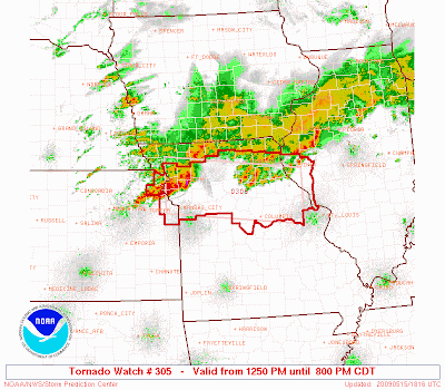
A tornado watch has been issued for central and northern Missouri until 8:00 p.m. Storms are expected to form and push into the area by late afternoon followed by a strong line of storms ahead of the advancing cold front.

Radar and Watch area as of 1:16 p.m.


I feel more confident of the severe weather panning out today as the cloud shield has stayed more to our north than it did on Wednesday, providing with much more sunshine and atmospheric instability. Currently the temperature is 5-6 degrees warmer than it was, and it feels plain muggy outside.

I'll update as I get the opportunity to.

Thursday, May 14, 2009

Storms Last Night


It was a busy day for meteorologists yesterday. There was much talk about a severe weather outbreak much of the day, and with each model analysis the confidence grew stronger and stronger.

Although the severe weather did pan out for northern Missouri, the central part of the state was spared from the worst weather. By nightfall, storms began to push east across mid-MO as the cold front drifted to the SE. We experienced lightning and some moderate rain as the main event rolled through, but that was it.

So what happened? I wish I knew...My best guess would have to do with the limited sunshine during the day. Most of the forecasters were saying that we would have a good 6-8 hours of sunshine, but the clouds hung tight all day in our area keeping the temperatures at bay.

As I stated above, there was some bad weather in northern Missouri. Colorado storm chaser Tony Laumbaugh and a crew chased in the area. He followed the storm and was able to be there for the tornadoes around Kirksville. Read his posts from the storm.

Monday, May 11, 2009

Ozark Flooding -- Ami's Blog!!

Short post today.

Flood pictures from Ami's new blog!

Bookmark it!

Have a great day!

Friday, May 8, 2009

A Stormy Night


A cold front moved southeast through the area overnight. Yesterday started out overcast, but the clouds all but cleared out and provided some good daytime heating, effectively cooking the atmosphere making conditions prime for thunderstorm development. By 4:00 p.m. two supercell storms formed in northeast MO and slowly made their way southeast. These two storms started off strong, spawning large hail reports and one tornado report in Daviess in NW Missouri. As the storms marched forward, they didn't let up, bringing numerous hail reports along the way. Finally, at 11:15 p.m., they reached our area.

Check out this impressive storm. You can see from the storm reports the path this storm took on its long journey. It was a well-organized supercell!


The strongest of the storm clipped us as it passed just to the south of this station. One spotter 3 miles south of Fulton reported 72 mph wind and 1/2" of rain in 15 minutes. We received only 0.36", lots of lightning, and for a time period of about 10 seconds we got rice-sized hail at 11:24. It occurred along with the heaviest rain. We didn't have any strong wind to report.

As the storm approached us, we were greeted with a spectacular lightning display! I got out our digital camera and tried my best to snap some pictures of the show. At times, the lightning would begin at the base of the clouds and sprawl out upwards and began as a "sunset orange" color. Here are some pics I was able to get. Most of them were very fuzzy, so they don't do the lightning justice. It was simply amazing.


The Morning After

As I left for work this morning, the sky was mostly clear with some high clouds left over from the night's storms. Before the next complex of storms rolled through the area, we were able to enjoy another beautiful sunrise. I'll never get tired of these.


Today's complex of storms brought some moderate rain to the area and some lightning, but nothing severe. Read Chris' CoCoRaHS blog for more on the storm that affected Southwest Missouri this morning.

Friday, May 1, 2009

April Weather Summary

April began by bringing some cold, rainy days...even two days with a trace of recorded snowfall! The temperatures weren't impressive -- below average at best -- and only surfacing above the average mark for only a brief moment or two. There was talk and fears of a damaging freeze reminiscent of the 2007 freeze event, but thankfully that threat subsided and only minor damage (if any) was reported.

Then how quickly the weather changed as warmer, more moist air began to dominate the area, and the entire midwest. In no time at all, we were up into the 80s, and this station we hit 90 for a brief moment. Overall, we ended up with slightly above average temperatures for the month.


Temperatures

High: 90°

Low: 29°

Mean High/Average: 67.5° / 65.9°

Mean Low/Average: 43.5° / 42.9°


Precipitation

It took some time to get the water works going, but a below-average April sky opened up late in the game and dumped some nice totals during the last week of the month. 62% of this fell in the last five days!

Thanks to OSNW3, I now have access to some midwest climate data! The average precipitation is data from the NWS coop station # 233079 in Fulton.

Average April Precip: 3.96"


We didn't have any severe events in April impact the area. In fact, in Missouri there were only 70 severe weather reports. I updated my previous post on April Storm Data to reflect this data.

April 2009 Days with Thunder: 3