Tuesday, April 28, 2009

Heavy Rain to End April

Last night was the first time we had a nice "spring" storm. The cold front that has been draped over the central plains for the past 5 days or so finally got a little push and made its way slowly through Missouri. We experienced some rain throughout the day, some moderate, but it came to an end by the afternoon.

At 6:30 the line of storms started to approach the area bringing with it heavy rain and lightning. AT 7:15, a beautiful shelf cloud came through...I didn't have my camera, so no picture. The upward lift and resulting condensation was awesome to watch as it passed over the house. The winds were doing some wicked things within the cloud.


5 Day Total / April Total So Far

1.99" / 4.28".....At MO-CW-1: 1.7 Mi. SSE Fulton
2.93" / 5.61".....At MO-CW-5: 0.3 Mi. ESE Auxvasse

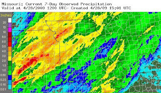
As mentioned before, this front has been draped over the nation's mid section for 5 days or so (not sure when it started), bringing with it some drenching rain for some, and even some snow for others.

Here is the current 7 day precip total for Missouri:


The front is not over impacting the state. It will begin to lift northward again tomorrow and impact our area with a warm front, bringing more chances for rain and storms through Friday. I will update then with a total precip for this event, and post the April Water Report.

Saturday, April 25, 2009

April Storm Data

I've been spending some time this week finding data on storms that occur in Missouri during April. It seems that this month is quite a transitional month with hard freezes, tornadoes, hail, and snow all occuring during the past 9 years.


---------------------------------------------

First, I checked back into my CoCoRaHS data since 4/07. I haven't been keeping track of days with thunder until this year, so my data consists of comparisons with my comments and those of other observers in Callaway and Boone counties.

Days with Thunder -- At MO-CW-1


- 2007: 4
- 2008: 7
- 2009: 1 (so far)


It is easy to see that 2008 was an active year. I don't remember it being especially stormy, but apparently it was compared to this year. I've only heard thunder once this month so far, and it was from a small cell that passed to our north one night a couple of weeks ago.

2007 was the year of the damaging freeze through the nation's mid-section, and Missouri was not spared from it. The National Weather Service compiled a comprehensive study into the meteorological conditions, and agricultural and horticultural impacts. If you've got some time to read the 52 page study, brew some coffee, sit down and enjoy.


---------------------------------------------

I was interested to find any data on severe weather events in Missouri that normally occur in April. That prompted me to dig into the NWS site for data, and I am amazed by the amount of information that they provide for the public. I seem to find something new every time I look around their site. All data comes from the Storm Prediction Center.

Number of Severe Weather Reports in Missouri (Tornado, High Wind, Hail)


For more information, including locations and divisions of each severe weather event, click on the links provided.


- 2000: 165
- 2001:
296
- 2002:
196
- 2003:
350
- 2004:
70
- 2005:
170
- 2006:
484
- 2007:
197
- 2008:
163
- 2009:
70

What an amazing contrast between 2004 and 2006! The predominant severe weather report seems to be hail. It should be noted that the hail criteria has changed this year to 1", in contrast with the previous size of .75". This will cause this year's severe hail reports to decline somewhat, but it seems as April, 2009 looks to be similar to 2004 with the reports predominantly located in southern Missouri. Of course, history shows us that one severe outbreak can increase this year's number, even double it!
Saturday, April 18, 2009

Weekend Update

After a cool start to the week, the sun came out and we got to enjoy some beautiful April weather. I think Missouri is one of the most beautiful places to live in the spring. The dogwoods are sprinkling the otherwise bare forest with its white flowers (signaling the time for prime Crappie fishing), and I love the purple hue that the redbud trees give to the forest edge by the highway on my way to and from work each day. I finally got out into the garden with my daughter to plant her first "garden" consisting of strawberries and marigolds. She's becoming so much like her daddy (she can even recognize and say anemometer now) ;o)

We're getting a good soaking rain at the moment, and are expected to during the weekend. Kind of a bummer because I still have LOTS to do outside in the yard, but it'll give the grass and garden some good rain to drink up. It's a nice light rain...very relaxing.

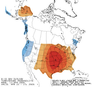
We are preparing, as is the rest of the middle of the nation, for quite a warm up next week!! Here's the Climate Prediction Center's 6-10 day outlook for temperature. After all the rain/snow that the mid-section is getting this weekend, the lawnmowers will be humming by Thursday, that's for sure!


It's interesting to note that we haven't experienced any days with thunder thus far in April. I am anxious to see what the rest of the month will bring. If I get some time this week, I'll dig back to the comments on the CoCoRaHS website to see how many storms we have had in the past two Aprils.

Monday, April 13, 2009

April Showers

Okay, I'm not one who normally complains about the weather. I can usually see the good in any type of weather, no matter the season. But I feel like we're stuck in a rut, a broken record of sorts with the cold and rainy conditions.

...but being the eternal optimist that I am, I know that our lower-than-average temperatures will give way to an upswing of warmer weather, and even an average day will feel like paradise! Here are the numbers for April so far:


-----------------------------------------------------

This Data For April 1 - 12 Only

Mean Average vs. Actual High: 63°/59
°
Mean Average vs. Actual Low: 40
°/34°

Precip: 2009 / 2008 / 2007

1.64" / 2.98" / 2.68

Days With Measurable Rain: 2009 / 2008 / 2007

5 / 8 / 5

-----------------------------------------------------

So far, even though the temperatures have been below average, we have not had the rain we normally do during the first half of April. We have had only 39% of our normal rainfall for the month. It makes me wonder if there is a correlation between an area having below-average temperatures and below-average precipitation. That would be a fun study.

Tuesday, April 7, 2009

Update on Freeze

It seems that we have been spared from a damaging freeze. I was anxious to wake up this morning and check the weather station. To my surprise, the lowest temperature recorded was 33°. There was a little frost on my car, but I wouldn't say that it was a heavy frost by any means.

Here's a roundup of the low temps last night in the area:

St. Louis - 33°
Columbia - 28°
Jeff City - 31°
Chesterfield - 33°
St. Charles - 33°
Farmington - 32°

It is a beautiful day outside witout a cloud in the sky. This morning's sunrise was amazing...truly a gift that I will never get tired of.

Monday, April 6, 2009

Freeze Warning Tonight

Today's weather story on the NWS St. Louis site resembles a mid-January story. A strong low pressure system passed through Missouri yesterday, and pulled some cold air behind it. We had our second bout of snow showers this spring last night. Nothing stuck to the ground, so officially I reported a trace for today's report.

A freeze warning has been issued for our area southern Missouri. A teacher I work with is expecting to loose her Apricot and Peach crop over the next two nights. Thankfully, her apples have not bloomed yet, so there is no danger with them yet.

Freeze Warning as stated from NWS STL:

AN UNSEASONABLY COLD AIRMASS WILL DOMINATE THE MID MISSISSIPPI VALLEY REGION UNTIL MID WEEK. AFTER ONE BOUT OF TEMPERATURES FALLING BELOW FREEZING THIS MORNING...LOOK FOR LOW TEMPERATURES IN THE MID TO UPPER 20S FOR SEVERAL HOURS ON MONDAY NIGHT AND EARLY TUESDAY WHICH MAY CAUSE A MORE WIDESPREAD HARD OR KILLING FREEZE ON TENDER VEGETATION.

THE COLD AIRMASS WILL BEGIN TO SLOWLY PULL AWAY FROM THE AREA ON TUESDAY NIGHT...BUT SKIES ARE EXPECTED TO BE CLEAR AND THE WINDS WILL BE RELATIVELY LIGHT. LOWS ARE STILL EXPECTED TO BE IN THE LOWER 30S...SO THE FREEZE WATCH REMAINS IN EFFECT.