Tuesday, March 31, 2009

March Water Report

March is over, and in typical Missouri style, it didn't leave without giving us a nice mixed bag of weather. Temperatures ranged from the 80s to the teens. We had only three days with thunder, which was surprising. This is the first month I've kept track of it, and I thought there would be more.

Temperatures

High: 84°

Low: 17°

Mean High/Average: 63.6°/55.1°

Mean Low/Average: 35.1°/33°


Precipitation

I assembled a table that compares this year's March precip with the past two:

Lift Off!
I came home, and noticed that the back patio was a bit different...our 6' patio table was gone!! We had some wind, but the max gust (that the station reported) was 26 mph. The table was upside down (it has a glass top, too), and 10 feet away from it's original spot! My best guess is that the wind blew against the house in just the right way and caused a gust to lift under the table and take it away! Scared my wife to death! (wish I could have seen it ;o)
March 27 and 28 Rain/Snow Recap

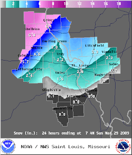
An impressively strong low pressure system, born in Colorado, caused quite a bit of headaches this week for some, and a nice spring snowfall for others. In my limited time to research this storm, I found some impressive snowfall totals and comments from CoCoRaHS observers.

For comments in the field, click HERE and search Kansas on 3/28/09.

This link from the NWS Dodge City, KS gives their Storm Recap, including amazing snowfall totals and the next day's visual satellite image.

At this station, we received 0.74" of precip, and 0.4" of snowfall. I had to measure the snowfall on my car because of our high ground temps (in the lower 50s). We received most of our rain from the northern swath of rain that preceeded the passing of the low. As the low passed to our east and northeast, enough cold air was pulled down to give us some sleet then moderate snowfall around 11:00 p.m.

Many thanks to OSNW3, a Wisconsin weather enthusiest, who put together a loop of this storm. You can view it HERE!

For a great blog on this storm, and Oshkosh, WI climatology, visit his blog (OSNW3)

I'll post the March stats for this station tomorrow.

Friday, March 27, 2009

Winter's Not Done Yet

With one last desperation shot, winter is trying to get the last word this weekend.


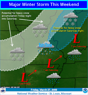
An area of low pressure is wreaking havoc on Colorado as I type, causing blizzard-like conditions. I saw on the news this morning a major pile up on a busy highway. Quite a storm they are contending with. This low pressure system is expected to travel SE through Texas and take a turn to the NE through southern MO.

The NWS office in St. Louis did it again...another wonderful addition to their website is a Multimedia Weather Briefing. It is currently in its experimental stages, but I have hopes that they will keep it on. Click HERE for the briefing.


As of 7:00 a.m. Friday, here is the projected snowfall amounts:


And a synopsis of the event...


Friday, March 20, 2009

HAPPY SPRING!


At 6:44 a.m. Central, the sun made it's way across the earth's equator. Days are getting longer now, and I'm hearing more birds in the morning. The sun is making its path higher and higher in the sky, which is making even the coldest of air masses no match to its warmth. The polar front is retreating to the north, and daytime instability will breed some intense storms in the near future.

I made sure to pack my camera this morning before heading to school. I've always wanted to snap some pictures during the equinox on the road by the school. It is an east-west road, and I love to watch the sun's shifting positions as it rises in different places throughout the year.

Friday, March 13, 2009

Quiet March So Far

Compared to some years, this has been a pretty calm March. Aside from a few storms we received between the 10th and 12th it has been quiet and (most recently) somewhat colder than average. My hopes for any snow is fading along with the fading hours of night, but the vision of warm humid air, thunderstorms, muggy mornings, mild nights, and digging in the garden with my daughter quickly replace this seasonal desire for the white snow.

Here is a rundown of our temps so far:


Friday, March 6, 2009

Wet Weekend Ahead

We have experienced quite a rebound of temperatures after a lower-than-average start to the week. Here's a rundown of our temperatures so far this week:

Monday: 43/17
Tuesday: 44/19
Wednesday: 67/25
Thursday: 82/52

One of the most notable characteristics of this weeks weather besides the warmer temperatures has been the amount of moisture that has advected up here. At Wednesday's reporting time of 6:00 a.m., the dew point temperature was at 45°, this was up from Tuesday's reading of 9°! This morning's (Friday) reading was 54°, so you can really feel the humidity start to permeate the air...which is going to cause our weather this weekend, hence the topic of this post.

Below is a picture from NWS STL that shows the position of the cold front as it passes through the area late Saturday night. There should be a couple waves of moisture pass through the area, one preceeding the fropa during the late evening hours, and the other after the front has passed through around midday Sunday. The threat for severe weather mainly persists for Saturday night, although it is mainly focused on North and Northwest Missouri at this time.


It looks like this system is poised to dump a good amount of moisture on the northern part of Missouri up into the great lakes area. Here is the 1-3 day QPF:


And the 5 day shows another system impacting the southern part of Missouri. At the time, it seems that we are sandwiched between systems and won't get the brunt of the heavy rain.


Tuesday, March 3, 2009

New Severe Storm Hail Criteria

The National Weather Service offices in the Central Region has implemented an increased hail size criteria for severe storms. Beginning this year, hail of 1" in diameter is needed in order for a storm to reach severe limits because of hail (the wind criteria of 58 mph. has remained the same). There has been discussion about this, and Kansas implemented a trial period of the change last year which prompted some positive responses.

Basically two reasons have spawned this change:

  • Current research shows that hail needs to be 1" to cause any real property damage


  • Too many storms reaching severe limits cause desensitization of the public when many severe storm warnings are posted. With fewer storm warnings, it is the NWS hopes that the public will take them more seriously.

Watch the informational video here.

Sunday, March 1, 2009

February Water Report

February precipitation can be summed up this way: All liquid.

Although we did have a trace or two end up on our sidewalks, we didn't experience a single measurable snow. Here's the recap and a comparison with last year at this station.

2009 / 2008

Total Precip: 2.68" / 4.50"
Snowfall: 0.0" / 5.9"
Days with Measurable Precipitation: 4 / 14
Days with Measureable Snowfall: 0 / 6
Days with Snow on Ground: 0 / 6

Another Trace in the Books

Another clipper system came tumbling down from the northwest yesterday. We have had a few of these this year, and every time, it has just grazed us just to the north. The result has always been a trace of snow for us.

This one promised a more western track, and the promise of more snow! Ultimately, the track was good, but in the end some dry air advected in from our northeast, which squelched our chances for some shoveling (and miniature snowmen that I was going to build with my daughter!)

Here are the snowfall totals.


Oh well...there is warmth headed our way. We should hit the 60s by Wednesday and even 70 by Friday. March is a good month for that. Heavy 6" snow one day, and flowers up the next.